Mezitli geodata
Mezitli (Mersin) is a seat of a second-order administrative division; located in Turkey in Europe/Istanbul (GMT+3) time zone. In our database, there are 1323 cities with bigger population. Compared to other cities in Turkey, 94.2% of cities are located further ↑North; 56.4% of cities are located further →East and 95.9% of cities have higher elevation than Mezitli. Note1


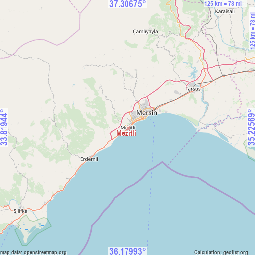
Mezitli GPS coordinates[2]
36° 44' 43.476" North, 34° 31' 21.216" East
| Map corner | latitude | longitude |
|---|---|---|
| Upper-left | 37.30675°, | 33.81944° |
| Center: | 36.74541°, | 34.52256° |
| Lower-right: | 36.17993°, | 35.22569° |
| Map W x H: | 125.3×125.3 km | = 77.9×77.9mi |
| max Lat: | 42.02683° ⇑94.2% North |
| Mezitli: | 36.74541° |
| min Lat: | ⇓5.8% South 35.9025° |
| min Long | Mezitli | max Long |
| 25.90902° | 34.52256° | 44.60099° |
| W 43.6%⇐ | ⇒56.4% E |
Elevation
Elevation of Mezitli is 14 m = 46 ft, and this is 703.4 m = 2308 ft below average elevation for this country.
| Max E: |
2682 m = 8799 ft | 95.9% |
| Avg. | 717.4 m = 2354 ft | |
| Mezitli | 14 m = 46 ft | |
Min E: |
0 m = 0 ft | 4.1% |
See also: Turkey elevation on elevation.city.
Geographical zone
Mezitli is located in North temperate zone (between Tropic of Cancer and the Arctic Circle). Distance of this Northern Tropic circle is 1479.8 km =919.5 mi to South.| Distance of | km | miles | from Mezitli |
|---|---|---|---|
| North Pole | 5921.4 | 3679.4 | to North |
| Arctic Circle | 3315.5 | 2060.2 | to North |
| Tropic Cancer | 1479.8 | 919.5 | to South |
| Equator | 4085.7 | 2538.7 | to South |


Nearby cities:
15 places around Mezitli: (largest is in red/bold)
• Arslanköy
36.9 km =22.9 mi,  325°
325°
• Elvanlı
14 km =8.7 mi,  250°
250°
• Erdemli
24.7 km =15.3 mi,  230°
230°
• Gözne
28.1 km =17.5 mi,  9°
9°
• Güzeloluk
39.6 km =24.6 mi,  277°
277°
• Kazanlı
22.3 km =13.9 mi,  69°
69°
• Kocahasanlı
28.5 km =17.7 mi, 231°
• Kuzucubelen
12.9 km =8 mi,  324°
324°
• Kızkalesi
46.3 km =28.8 mi, 227°
• Mersin
12.7 km =7.9 mi,  54°
54°
• Pınarbaşı
15 km =9.3 mi, 251°
• Tarsus
38.1 km =23.7 mi,  59°
59°
• Tuzla
50.6 km =31.4 mi,  95°
95°
• Yenice
53.7 km =33.4 mi, 61°
• Çamlıyayla
47.2 km =29.3 mi, 7°
Sources, notices
• [Note1] Compared only with cities in Turkey existing in our database
• [Src1] Map data: © OpenStreetMap contributors (CC-BY-SA)
• [Src2] Other city data from geonames.org with taken over terms of usage.
• [Src3] Geographical zone / Annual Mean Temperature by Robert A. Rohde @ Wikipedia
