Elvanlı geodata
Elvanlı (Mersin) is a seat of a third-order administrative division; located in Turkey in Europe/Istanbul (GMT+3) time zone. With population of 2,143 people, there are 933 cities with bigger population in this country. Compared to other cities in Turkey, 95.1% of cities are located further ↑North; 57.1% of cities are located further →East and 75.7% of cities have higher elevation than Elvanlı. Note1


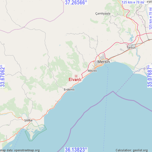
Elvanlı GPS coordinates[2]
36° 42' 14.436" North, 34° 22' 25.464" East
| Map corner | latitude | longitude |
|---|---|---|
| Upper-left | 37.26566°, | 33.67062° |
| Center: | 36.70401°, | 34.37374° |
| Lower-right: | 36.13823°, | 35.07687° |
| Map W x H: | 125.4×125.4 km | = 77.9×77.9mi |
| max Lat: | 42.02683° ⇑95.1% North |
| Elvanlı: | 36.70401° |
| min Lat: | ⇓4.9% South 35.9025° |
| min Long | Elvanlı | max Long |
| 25.90902° | 34.37374° | 44.60099° |
| W 42.9%⇐ | ⇒57.1% E |
Elevation
Elevation of Elvanlı is 166 m = 545 ft, and this is 551.4 m = 1809 ft below average elevation for this country.
| Max E: |
2682 m = 8799 ft | 75.7% |
| Avg. | 717.4 m = 2354 ft | |
| Elvanlı | 166 m = 545 ft | |
Min E: |
0 m = 0 ft | 24.3% |
See also: Turkey elevation on elevation.city.
Geographical zone
Elvanlı is located in North temperate zone (between Tropic of Cancer and the Arctic Circle). Distance of this Northern Tropic circle is 1475.2 km =916.6 mi to South.| Distance of | km | miles | from Elvanlı |
|---|---|---|---|
| North Pole | 5926 | 3682.2 | to North |
| Arctic Circle | 3320.1 | 2063 | to North |
| Tropic Cancer | 1475.2 | 916.6 | to South |
| Equator | 4081.1 | 2535.9 | to South |


Nearby cities:
15 places around Elvanlı: (largest is in red/bold)
• Arslanköy
35.8 km =22.2 mi,  347°
347°
• Erdemli
12.5 km =7.8 mi,  207°
207°
• Gözne
36.9 km =22.9 mi,  28°
28°
• Güzeloluk
27.8 km =17.3 mi,  291°
291°
• Kazanlı
36.4 km =22.6 mi,  70°
70°
• Kocahasanlı
16 km =9.9 mi, 213°
• Kuzucubelen
16.2 km =10.1 mi,  20°
20°
• Kırobası
45.2 km =28.1 mi,  272°
272°
• Kızkalesi
34 km =21.1 mi,  217°
217°
• Mersin
26.5 km =16.5 mi,  63°
63°
• Mezitli
14 km =8.7 mi, 70°
• Pınarbaşı
1 km =0.6 mi, 266°
• Silifke
53.4 km =33.2 mi,  227°
227°
• Tarsus
52 km =32.3 mi, 62°
• Çamlıyayla
55 km =34.2 mi, 20°
Sources, notices
• [Note1] Compared only with cities in Turkey existing in our database
• [Src1] Map data: © OpenStreetMap contributors (CC-BY-SA)
• [Src2] Other city data from geonames.org with taken over terms of usage.
• [Src3] Geographical zone / Annual Mean Temperature by Robert A. Rohde @ Wikipedia
