Tuzla geodata
Tuzla (Adana) is a seat of a third-order administrative division; located in Turkey in Europe/Istanbul (GMT+3) time zone. In our database, there are 1323 cities with bigger population. Compared to other cities in Turkey, 95.3% of cities are located further ↑North; 53.9% of cities are located further →East and 99.6% of cities have higher elevation than Tuzla. Note1


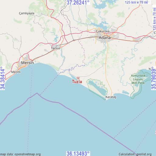
Tuzla GPS coordinates[2]
36° 42' 2.664" North, 35° 5' 14.136" East
| Map corner | latitude | longitude |
|---|---|---|
| Upper-left | 37.26241°, | 34.38414° |
| Center: | 36.70074°, | 35.08726° |
| Lower-right: | 36.13493°, | 35.79039° |
| Map W x H: | 125.4×125.4 km | = 77.9×77.9mi |
| max Lat: | 42.02683° ⇑95.3% North |
| Tuzla: | 36.70074° |
| min Lat: | ⇓4.7% South 35.9025° |
| min Long | Tuzla | max Long |
| 25.90902° | 35.08726° | 44.60099° |
| W 46.1%⇐ | ⇒53.9% E |
Elevation
Elevation of Tuzla is 4 m = 13 ft, and this is 713.4 m = 2341 ft below average elevation for this country.
| Max E: |
2682 m = 8799 ft | 99.6% |
| Avg. | 717.4 m = 2354 ft | |
| Tuzla | 4 m = 13 ft | |
Min E: |
0 m = 0 ft | 0.4% |
See also: Turkey elevation on elevation.city.
Geographical zone
Tuzla is located in North temperate zone (between Tropic of Cancer and the Arctic Circle). Distance of this Northern Tropic circle is 1474.8 km =916.4 mi to South.| Distance of | km | miles | from Tuzla |
|---|---|---|---|
| North Pole | 5926.3 | 3682.4 | to North |
| Arctic Circle | 3320.4 | 2063.2 | to North |
| Tropic Cancer | 1474.8 | 916.4 | to South |
| Equator | 4080.7 | 2535.6 | to South |


Nearby cities:
15 places around Tuzla: (largest is in red/bold)
• Adana
39.8 km =24.7 mi,  32°
32°
• Doğankent
27.9 km =17.3 mi,  55°
55°
• Gözne
56.3 km =35 mi,  305°
305°
• Karaisalı
61.9 km =38.5 mi,  357°
357°
• Karataş
28.5 km =17.7 mi,  117°
117°
• Kazanlı
32 km =19.9 mi,  293°
293°
• Kuzucubelen
59.9 km =37.2 mi,  284°
284°
• Mersin
41.8 km =26 mi, 287°
• Mezitli
50.6 km =31.4 mi, 275°
• Sarıçam
62.5 km =38.8 mi,  36°
36°
• Seyhan
37.3 km =23.2 mi, 31°
• Tarsus
29.7 km =18.5 mi,  324°
324°
• Yakapınar
56.3 km =35 mi, 57°
• Yenice
30.9 km =19.2 mi,  354°
354°
• Yüreğir
38.9 km =24.2 mi, 38°
Sources, notices
• [Note1] Compared only with cities in Turkey existing in our database
• [Src1] Map data: © OpenStreetMap contributors (CC-BY-SA)
• [Src2] Other city data from geonames.org with taken over terms of usage.
• [Src3] Geographical zone / Annual Mean Temperature by Robert A. Rohde @ Wikipedia
