Kızkalesi geodata
Kızkalesi (Hatay) is a populated place; located in Turkey in Europe/Istanbul (GMT+3) time zone. With population of 1,742 people, there are 985 cities with bigger population in this country. Compared to other cities in Turkey, 97.1% of cities are located further ↑North; 57.9% of cities are located further →East and 98.3% of cities have higher elevation than Kızkalesi. Note1


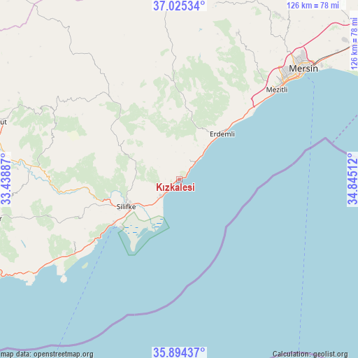
Kızkalesi GPS coordinates[2]
36° 27' 42.912" North, 34° 8' 31.164" East
| Map corner | latitude | longitude |
|---|---|---|
| Upper-left | 37.02534°, | 33.43887° |
| Center: | 36.46192°, | 34.14199° |
| Lower-right: | 35.89437°, | 34.84512° |
| Map W x H: | 125.8×125.8 km | = 78.2×78.2mi |
| max Lat: | 42.02683° ⇑97.1% North |
| Kızkalesi: | 36.46192° |
| min Lat: | ⇓2.9% South 35.9025° |
| min Long | Kızkalesi | max Long |
| 25.90902° | 34.14199° | 44.60099° |
| W 42.1%⇐ | ⇒57.9% E |
Elevation
Elevation of Kızkalesi is 9 m = 30 ft, and this is 708.4 m = 2324 ft below average elevation for this country.
| Max E: |
2682 m = 8799 ft | 98.3% |
| Avg. | 717.4 m = 2354 ft | |
| Kızkalesi | 9 m = 30 ft | |
Min E: |
0 m = 0 ft | 1.7% |
See also: Turkey elevation on elevation.city.
Geographical zone
Kızkalesi is located in North temperate zone (between Tropic of Cancer and the Arctic Circle). Distance of this Northern Tropic circle is 1448.3 km =899.9 mi to South.| Distance of | km | miles | from Kızkalesi |
|---|---|---|---|
| North Pole | 5952.9 | 3699 | to North |
| Arctic Circle | 3347 | 2079.7 | to North |
| Tropic Cancer | 1448.3 | 899.9 | to South |
| Equator | 4054.2 | 2519.2 | to South |


Nearby cities:
15 places around Kızkalesi: (largest is in red/bold)
• Akdere
42.8 km =26.6 mi,  234°
234°
• Arslanköy
63.3 km =39.3 mi,  11°
11°
• Elvanlı
34 km =21.1 mi,  37°
37°
• Erdemli
21.8 km =13.5 mi, 43°
• Güzeloluk
37.3 km =23.2 mi,  351°
351°
• Kocahasanlı
18 km =11.2 mi, 40°
• Kuzucubelen
49.6 km =30.8 mi,  32°
32°
• Kırobası
38 km =23.6 mi,  319°
319°
• Mersin
59 km =36.7 mi,  48°
48°
• Mezitli
46.3 km =28.8 mi, 47°
• Ovacık
61.7 km =38.3 mi,  238°
238°
• Pınarbaşı
33.3 km =20.7 mi, 36°
• Sarıkavak
46.5 km =28.9 mi,  286°
286°
• Silifke
20.8 km =12.9 mi, 243°
• Taşucu
28.1 km =17.5 mi, 236°
Sources, notices
• [Note1] Compared only with cities in Turkey existing in our database
• [Src1] Map data: © OpenStreetMap contributors (CC-BY-SA)
• [Src2] Other city data from geonames.org with taken over terms of usage.
• [Src3] Geographical zone / Annual Mean Temperature by Robert A. Rohde @ Wikipedia
