Çamlıyayla geodata
Çamlıyayla (Mersin) is a seat of a second-order administrative division; located in Turkey in Europe/Istanbul (GMT+3) time zone. In our database, there are 1323 cities with bigger population. Compared to other cities in Turkey, 84.5% of cities are located further ↑North; 56% of cities are located further →East and 77.7% of cities have lower elevation than Çamlıyayla. Note1


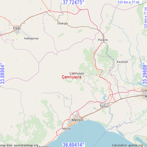
Çamlıyayla GPS coordinates[2]
37° 9' 59.472" North, 34° 35' 34.656" East
| Map corner | latitude | longitude |
|---|---|---|
| Upper-left | 37.72475°, | 33.88984° |
| Center: | 37.16652°, | 34.59296° |
| Lower-right: | 36.60414°, | 35.29609° |
| Map W x H: | 124.6×124.6 km | = 77.4×77.4mi |
| max Lat: | 42.02683° ⇑84.5% North |
| Çamlıyayla: | 37.16652° |
| min Lat: | ⇓15.5% South 35.9025° |
| min Long | Çamlıyayla | max Long |
| 25.90902° | 34.59296° | 44.60099° |
| W 44%⇐ | ⇒56% E |
Elevation
Elevation of Çamlıyayla is 1149 m = 3770 ft, and this is 431.6 m = 1416 ft above average elevation for this country.
| Max E: |
2682 m = 8799 ft | 22.3% |
| Çamlıyayla | 1149 m 3770 ft | |
| Avg. | 717.4 m = 2354 ft | |
Min E: |
0 m = 0 ft | 77.7% |
See also: Turkey elevation on elevation.city.
Geographical zone
Çamlıyayla is located in North temperate zone (between Tropic of Cancer and the Arctic Circle). Distance of this Northern Tropic circle is 1526.6 km =948.6 mi to South.| Distance of | km | miles | from Çamlıyayla |
|---|---|---|---|
| North Pole | 5874.5 | 3650.2 | to North |
| Arctic Circle | 3268.6 | 2031 | to North |
| Tropic Cancer | 1526.6 | 948.6 | to South |
| Equator | 4132.5 | 2567.8 | to South |


Nearby cities:
15 places around Çamlıyayla: (largest is in red/bold)
• Arslanköy
31.7 km =19.7 mi,  238°
238°
• Elvanlı
55 km =34.2 mi,  200°
200°
• Gözne
19.1 km =11.9 mi,  185°
185°
• Halkapınar
46.6 km =29 mi,  309°
309°
• Kamışlı
53.4 km =33.2 mi,  35°
35°
• Karaisalı
42.5 km =26.4 mi,  76°
76°
• Kazanlı
41.7 km =25.9 mi,  159°
159°
• Kuzucubelen
38.8 km =24.1 mi, 200°
• Mersin
39.6 km =24.6 mi,  174°
174°
• Mezitli
47.2 km =29.3 mi, 187°
• Pozantı
38.1 km =23.7 mi, 40°
• Tarsus
38.4 km =23.9 mi,  136°
136°
• Ulukışla
43.4 km =27 mi,  347°
347°
• Yenice
45.8 km =28.5 mi,  117°
117°
• Çiftehan
41.5 km =25.8 mi,  22°
22°
Sources, notices
• [Note1] Compared only with cities in Turkey existing in our database
• [Src1] Map data: © OpenStreetMap contributors (CC-BY-SA)
• [Src2] Other city data from geonames.org with taken over terms of usage.
• [Src3] Geographical zone / Annual Mean Temperature by Robert A. Rohde @ Wikipedia
