Kızılkaya geodata
Kızılkaya (Burdur) is a populated place; located in Turkey in Europe/Istanbul (GMT+3) time zone. With population of 1,860 people, there are 975 cities with bigger population in this country. Compared to other cities in Turkey, 80.3% of cities are located further ↑North; 73.5% of cities are located further →East and 55.6% of cities have lower elevation than Kızılkaya. Note1


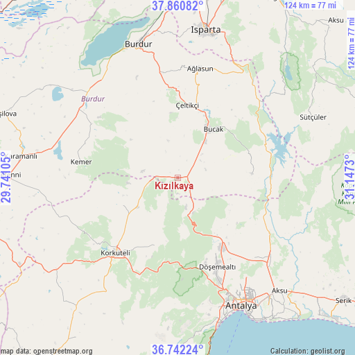
Kızılkaya GPS coordinates[2]
37° 18' 12.996" North, 30° 26' 39.012" East
| Map corner | latitude | longitude |
|---|---|---|
| Upper-left | 37.86082°, | 29.74105° |
| Center: | 37.30361°, | 30.44417° |
| Lower-right: | 36.74224°, | 31.1473° |
| Map W x H: | 124.4×124.4 km | = 77.3×77.3mi |
| max Lat: | 42.02683° ⇑80.3% North |
| Kızılkaya: | 37.30361° |
| min Lat: | ⇓19.7% South 35.9025° |
| min Long | Kızılkaya | max Long |
| 25.90902° | 30.44417° | 44.60099° |
| W 26.5%⇐ | ⇒73.5% E |
Elevation
Elevation of Kızılkaya is 800 m = 2625 ft, and this is 82.6 m = 271 ft above average elevation for this country.
| Max E: |
2682 m = 8799 ft | 44.4% |
| Kızılkaya | 800 m 2625 ft | |
| Avg. | 717.4 m = 2354 ft | |
Min E: |
0 m = 0 ft | 55.6% |
See also: Turkey elevation on elevation.city.
Geographical zone
Kızılkaya is located in North temperate zone (between Tropic of Cancer and the Arctic Circle). Distance of this Northern Tropic circle is 1541.9 km =958.1 mi to South.| Distance of | km | miles | from Kızılkaya |
|---|---|---|---|
| North Pole | 5859.3 | 3640.8 | to North |
| Arctic Circle | 3253.4 | 2021.6 | to North |
| Tropic Cancer | 1541.9 | 958.1 | to South |
| Equator | 4147.8 | 2577.3 | to South |


Nearby cities:
15 places around Kızılkaya: (largest is in red/bold)
• Antalya
49.3 km =30.6 mi,  153°
153°
• Ağlasun
39.3 km =24.4 mi,  11°
11°
• Bozova
17.1 km =10.6 mi,  235°
235°
• Bucak
21.8 km =13.5 mi,  37°
37°
• Burdur
48.3 km =30 mi,  343°
343°
• Dağ
13.4 km =8.3 mi,  156°
156°
• Döşemealtı
34.2 km =21.3 mi, 155°
• Gebiz
49 km =30.4 mi,  116°
116°
• Geyikbayırı
47.6 km =29.6 mi,  178°
178°
• Kemer
34.1 km =21.2 mi,  279°
279°
• Kepez
49.1 km =30.5 mi, 151°
• Kocaaliler
26.2 km =16.3 mi,  86°
86°
• Korkuteli
34.5 km =21.4 mi,  219°
219°
• Çakırlar
49.2 km =30.6 mi,  167°
167°
• Çeltikçi
25.3 km =15.7 mi, 7°
Sources, notices
• [Note1] Compared only with cities in Turkey existing in our database
• [Src1] Map data: © OpenStreetMap contributors (CC-BY-SA)
• [Src2] Other city data from geonames.org with taken over terms of usage.
• [Src3] Geographical zone / Annual Mean Temperature by Robert A. Rohde @ Wikipedia
