Geyikbayırı geodata
Geyikbayırı (Antalya) is a populated place; located in Turkey in Europe/Istanbul (GMT+3) time zone. With population of 975 people, there are 1094 cities with bigger population in this country. Compared to other cities in Turkey, 91.2% of cities are located further ↑North; 73.4% of cities are located further →East and 50.5% of cities have lower elevation than Geyikbayırı. Note1


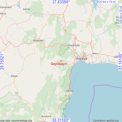
Geyikbayırı GPS coordinates[2]
36° 52' 32.016" North, 30° 27' 29.988" East
| Map corner | latitude | longitude |
|---|---|---|
| Upper-left | 37.43594°, | 29.75521° |
| Center: | 36.87556°, | 30.45833° |
| Lower-right: | 36.31103°, | 31.16146° |
| Map W x H: | 125.1×125.1 km | = 77.7×77.7mi |
| max Lat: | 42.02683° ⇑91.2% North |
| Geyikbayırı: | 36.87556° |
| min Lat: | ⇓8.8% South 35.9025° |
| min Long | Geyikbayırı | max Long |
| 25.90902° | 30.45833° | 44.60099° |
| W 26.6%⇐ | ⇒73.4% E |
Elevation
Elevation of Geyikbayırı is 702 m = 2303 ft, and this is 15.4 m = 51 ft below average elevation for this country.
| Max E: |
2682 m = 8799 ft | 49.5% |
| Avg. | 717.4 m = 2354 ft | |
| Geyikbayırı | 702 m = 2303 ft | |
Min E: |
0 m = 0 ft | 50.5% |
See also: Turkey elevation on elevation.city.
Geographical zone
Geyikbayırı is located in North temperate zone (between Tropic of Cancer and the Arctic Circle). Distance of this Northern Tropic circle is 1494.3 km =928.5 mi to South.| Distance of | km | miles | from Geyikbayırı |
|---|---|---|---|
| North Pole | 5906.9 | 3670.4 | to North |
| Arctic Circle | 3301 | 2051.1 | to North |
| Tropic Cancer | 1494.3 | 928.5 | to South |
| Equator | 4100.2 | 2547.7 | to South |


Nearby cities:
15 places around Geyikbayırı: (largest is in red/bold)
• Aksu
35.7 km =22.2 mi,  75°
75°
• Altınyaka
36.6 km =22.7 mi,  195°
195°
• Antalya
21.4 km =13.3 mi, 80°
• Bozova
40.8 km =25.4 mi,  337°
337°
• Dağ
35.5 km =22.1 mi,  6°
6°
• Döşemealtı
20.8 km =12.9 mi,  37°
37°
• Gölova
38.3 km =23.8 mi,  257°
257°
• Göynük
25.3 km =15.7 mi,  161°
161°
• Kemer
32.2 km =20 mi, 163°
• Kepez
22.6 km =14 mi, 78°
• Konyaaltı
15.3 km =9.5 mi,  93°
93°
• Korkuteli
31.4 km =19.5 mi,  312°
312°
• Muratpaşa
27.3 km =17 mi, 86°
• Tekirova
42 km =26.1 mi,  171°
171°
• Çakırlar
9.2 km =5.7 mi, 92°
Sources, notices
• [Note1] Compared only with cities in Turkey existing in our database
• [Src1] Map data: © OpenStreetMap contributors (CC-BY-SA)
• [Src2] Other city data from geonames.org with taken over terms of usage.
• [Src3] Geographical zone / Annual Mean Temperature by Robert A. Rohde @ Wikipedia
