Kemer geodata
Kemer (Burdur) is a seat of a second-order administrative division; located in Turkey in Europe/Istanbul (GMT+3) time zone. With population of 2,217 people, there are 920 cities with bigger population in this country. Compared to other cities in Turkey, 79.1% of cities are located further ↑North; 75.3% of cities are located further →East and 78.7% of cities have lower elevation than Kemer. Note1


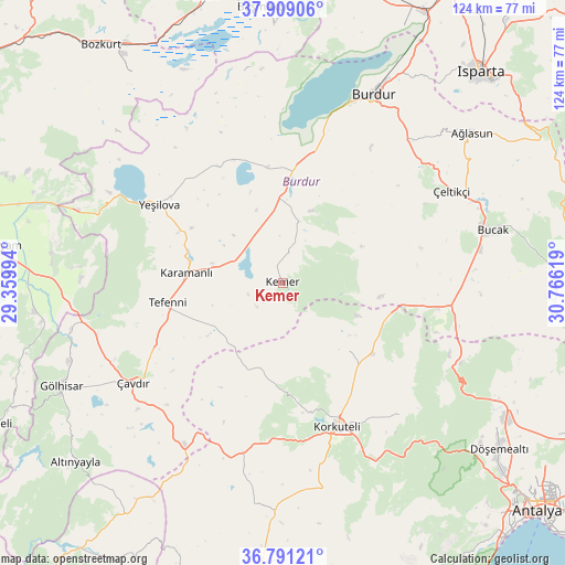
Kemer GPS coordinates[2]
37° 21' 7.992" North, 30° 3' 47.016" East
| Map corner | latitude | longitude |
|---|---|---|
| Upper-left | 37.90906°, | 29.35994° |
| Center: | 37.35222°, | 30.06306° |
| Lower-right: | 36.79121°, | 30.76619° |
| Map W x H: | 124.3×124.3 km | = 77.2×77.2mi |
| max Lat: | 42.02683° ⇑79.1% North |
| Kemer: | 37.35222° |
| min Lat: | ⇓20.9% South 35.9025° |
| min Long | Kemer | max Long |
| 25.90902° | 30.06306° | 44.60099° |
| W 24.7%⇐ | ⇒75.3% E |
Elevation
Elevation of Kemer is 1168 m = 3832 ft, and this is 450.6 m = 1478 ft above average elevation for this country.
| Max E: |
2682 m = 8799 ft | 21.3% |
| Kemer | 1168 m 3832 ft | |
| Avg. | 717.4 m = 2354 ft | |
Min E: |
0 m = 0 ft | 78.7% |
See also: Turkey elevation on elevation.city.
Geographical zone
Kemer is located in North temperate zone (between Tropic of Cancer and the Arctic Circle). Distance of this Northern Tropic circle is 1547.3 km =961.4 mi to South.| Distance of | km | miles | from Kemer |
|---|---|---|---|
| North Pole | 5853.9 | 3637.4 | to North |
| Arctic Circle | 3248 | 2018.2 | to North |
| Tropic Cancer | 1547.3 | 961.4 | to South |
| Equator | 4153.2 | 2580.7 | to South |


Nearby cities:
15 places around Kemer: (largest is in red/bold)
• Ağlasun
53.1 km =33 mi,  51°
51°
• Bozova
24.8 km =15.4 mi,  127°
127°
• Bucak
48.5 km =30.1 mi,  75°
75°
• Burdur
45.6 km =28.3 mi,  26°
26°
• Dağ
42.9 km =26.7 mi,  114°
114°
• Gölhisar
54.2 km =33.7 mi,  244°
244°
• Karamanlı
21.3 km =13.2 mi,  276°
276°
• Kocaaliler
60 km =37.3 mi,  93°
93°
• Korkuteli
34 km =21.1 mi,  159°
159°
• Kızılcadağ
38.3 km =23.8 mi,  193°
193°
• Kızılkaya
34.1 km =21.2 mi,  99°
99°
• Tefenni
25.9 km =16.1 mi,  259°
259°
• Yeşilova
32.3 km =20.1 mi,  302°
302°
• Çavdır
39.3 km =24.4 mi, 236°
• Çeltikçi
41.8 km =26 mi,  61°
61°
Sources, notices
• [Note1] Compared only with cities in Turkey existing in our database
• [Src1] Map data: © OpenStreetMap contributors (CC-BY-SA)
• [Src2] Other city data from geonames.org with taken over terms of usage.
• [Src3] Geographical zone / Annual Mean Temperature by Robert A. Rohde @ Wikipedia
