Dağ geodata
Dağ (Antalya) is a seat of a third-order administrative division; located in Turkey in Europe/Istanbul (GMT+3) time zone. In our database, there are 1323 cities with bigger population. Compared to other cities in Turkey, 83.6% of cities are located further ↑North; 73.2% of cities are located further →East and 55.4% of cities have lower elevation than Dağ. Note1


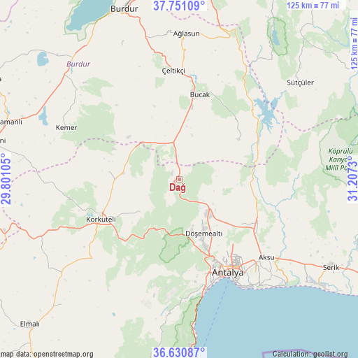
Dağ GPS coordinates[2]
37° 11' 35.016" North, 30° 30' 15.012" East
| Map corner | latitude | longitude |
|---|---|---|
| Upper-left | 37.75109°, | 29.80105° |
| Center: | 37.19306°, | 30.50417° |
| Lower-right: | 36.63087°, | 31.2073° |
| Map W x H: | 124.6×124.6 km | = 77.4×77.4mi |
| max Lat: | 42.02683° ⇑83.6% North |
| Dağ: | 37.19306° |
| min Lat: | ⇓16.4% South 35.9025° |
| min Long | Dağ | max Long |
| 25.90902° | 30.50417° | 44.60099° |
| W 26.8%⇐ | ⇒73.2% E |
Elevation
Elevation of Dağ is 797 m = 2615 ft, and this is 79.6 m = 261 ft above average elevation for this country.
| Max E: |
2682 m = 8799 ft | 44.6% |
| Dağ | 797 m 2615 ft | |
| Avg. | 717.4 m = 2354 ft | |
Min E: |
0 m = 0 ft | 55.4% |
See also: Turkey elevation on elevation.city.
Geographical zone
Dağ is located in North temperate zone (between Tropic of Cancer and the Arctic Circle). Distance of this Northern Tropic circle is 1529.6 km =950.4 mi to South.| Distance of | km | miles | from Dağ |
|---|---|---|---|
| North Pole | 5871.6 | 3648.4 | to North |
| Arctic Circle | 3265.7 | 2029.2 | to North |
| Tropic Cancer | 1529.6 | 950.4 | to South |
| Equator | 4135.5 | 2569.7 | to South |


Nearby cities:
15 places around Dağ: (largest is in red/bold)
• Aksu
40.5 km =25.2 mi,  131°
131°
• Antalya
35.9 km =22.3 mi,  151°
151°
• Bozova
19.5 km =12.1 mi,  277°
277°
• Bucak
30.7 km =19.1 mi,  15°
15°
• Döşemealtı
20.8 km =12.9 mi,  155°
155°
• Gebiz
39.7 km =24.7 mi,  104°
104°
• Geyikbayırı
35.5 km =22.1 mi,  186°
186°
• Kepez
35.7 km =22.2 mi, 149°
• Kocaaliler
25 km =15.5 mi,  56°
56°
• Konyaaltı
38 km =23.6 mi, 162°
• Korkuteli
30.8 km =19.1 mi,  242°
242°
• Kızılkaya
13.4 km =8.3 mi,  336°
336°
• Muratpaşa
40.7 km =25.3 mi, 145°
• Çakırlar
36.1 km =22.4 mi,  171°
171°
• Çeltikçi
37.5 km =23.3 mi,  356°
356°
Sources, notices
• [Note1] Compared only with cities in Turkey existing in our database
• [Src1] Map data: © OpenStreetMap contributors (CC-BY-SA)
• [Src2] Other city data from geonames.org with taken over terms of usage.
• [Src3] Geographical zone / Annual Mean Temperature by Robert A. Rohde @ Wikipedia
