Bucak geodata
Bucak (Burdur) is a seat of a second-order administrative division; located in Turkey in Europe/Istanbul (GMT+3) time zone. With population of 29,234 people, there are 257 cities with bigger population in this country. Compared to other cities in Turkey, 75.9% of cities are located further ↑North; 72.3% of cities are located further →East and 56.5% of cities have lower elevation than Bucak. Note1


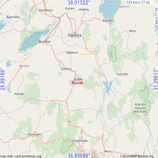
Bucak GPS coordinates[2]
37° 27' 33.012" North, 30° 35' 42" East
| Map corner | latitude | longitude |
|---|---|---|
| Upper-left | 38.01522°, | 29.89188° |
| Center: | 37.45917°, | 30.595° |
| Lower-right: | 36.89896°, | 31.29813° |
| Map W x H: | 124.1×124.1 km | = 77.1×77.1mi |
| max Lat: | 42.02683° ⇑75.9% North |
| Bucak: | 37.45917° |
| min Lat: | ⇓24.1% South 35.9025° |
| min Long | Bucak | max Long |
| 25.90902° | 30.595° | 44.60099° |
| W 27.7%⇐ | ⇒72.3% E |
Elevation
Elevation of Bucak is 819 m = 2687 ft, and this is 101.6 m = 333 ft above average elevation for this country.
| Max E: |
2682 m = 8799 ft | 43.5% |
| Bucak | 819 m 2687 ft | |
| Avg. | 717.4 m = 2354 ft | |
Min E: |
0 m = 0 ft | 56.5% |
See also: Turkey elevation on elevation.city.
Geographical zone
Bucak is located in North temperate zone (between Tropic of Cancer and the Arctic Circle). Distance of this Northern Tropic circle is 1559.2 km =968.8 mi to South.| Distance of | km | miles | from Bucak |
|---|---|---|---|
| North Pole | 5842 | 3630 | to North |
| Arctic Circle | 3236.1 | 2010.8 | to North |
| Tropic Cancer | 1559.2 | 968.8 | to South |
| Equator | 4165.1 | 2588.1 | to South |


Nearby cities:
15 places around Bucak: (largest is in red/bold)
• Anamas
38.7 km =24 mi,  27°
27°
• Ağlasun
21.8 km =13.5 mi,  345°
345°
• Bozova
38.4 km =23.9 mi,  225°
225°
• Burdur
39.5 km =24.5 mi,  317°
317°
• Dağ
30.7 km =19.1 mi,  195°
195°
• Döşemealtı
48.5 km =30.1 mi,  179°
179°
• Eğirdir
51.4 km =31.9 mi, 25°
• Gebiz
49.8 km =30.9 mi,  142°
142°
• Isparta
34.2 km =21.3 mi, 353°
• Kasımlar
53.3 km =33.1 mi,  81°
81°
• Kemer
48.5 km =30.1 mi,  255°
255°
• Kocaaliler
20.4 km =12.7 mi, 140°
• Kızılkaya
21.8 km =13.5 mi,  217°
217°
• Pavlu Cebel
34 km =21.1 mi, 82°
• Çeltikçi
12.8 km =8 mi,  307°
307°
Sources, notices
• [Note1] Compared only with cities in Turkey existing in our database
• [Src1] Map data: © OpenStreetMap contributors (CC-BY-SA)
• [Src2] Other city data from geonames.org with taken over terms of usage.
• [Src3] Geographical zone / Annual Mean Temperature by Robert A. Rohde @ Wikipedia
