Kiraz geodata
Kiraz (İzmir) is a seat of a second-order administrative division; located in Turkey in Europe/Istanbul (GMT+3) time zone. With population of 11,718 people, there are 460 cities with bigger population in this country. Compared to other cities in Turkey, 57.6% of cities are located further ↑North; 88.7% of cities are located further →East and 69.9% of cities have higher elevation than Kiraz. Note1


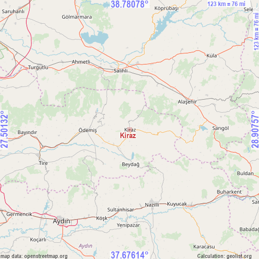
Kiraz GPS coordinates[2]
38° 13' 50.016" North, 28° 12' 15.984" East
| Map corner | latitude | longitude |
|---|---|---|
| Upper-left | 38.78078°, | 27.50132° |
| Center: | 38.23056°, | 28.20444° |
| Lower-right: | 37.67614°, | 28.90757° |
| Map W x H: | 122.8×122.8 km | = 76.3×76.3mi |
| max Lat: | 42.02683° ⇑57.6% North |
| Kiraz: | 38.23056° |
| min Lat: | ⇓42.4% South 35.9025° |
| min Long | Kiraz | max Long |
| 25.90902° | 28.20444° | 44.60099° |
| W 11.3%⇐ | ⇒88.7% E |
Elevation
Elevation of Kiraz is 305 m = 1001 ft, and this is 412.4 m = 1353 ft below average elevation for this country.
| Max E: |
2682 m = 8799 ft | 69.9% |
| Avg. | 717.4 m = 2354 ft | |
| Kiraz | 305 m = 1001 ft | |
Min E: |
0 m = 0 ft | 30.1% |
See also: Turkey elevation on elevation.city.
Geographical zone
Kiraz is located in North temperate zone (between Tropic of Cancer and the Arctic Circle). Distance of this Northern Tropic circle is 1644.9 km =1022.1 mi to South.| Distance of | km | miles | from Kiraz |
|---|---|---|---|
| North Pole | 5756.2 | 3576.7 | to North |
| Arctic Circle | 3150.3 | 1957.5 | to North |
| Tropic Cancer | 1644.9 | 1022.1 | to South |
| Equator | 4250.8 | 2641.3 | to South |


Nearby cities:
15 places around Kiraz: (largest is in red/bold)
• Alaşehir
30.4 km =18.9 mi,  63°
63°
• Atça
38 km =23.6 mi,  178°
178°
• Bademli
20.9 km =13 mi,  217°
217°
• Birgi
12.9 km =8 mi,  279°
279°
• Gökçen
31.9 km =19.8 mi,  245°
245°
• Kaymakçı
10.5 km =6.5 mi,  228°
228°
• Konaklı
22.4 km =13.9 mi, 234°
• Nazilli
36.4 km =22.6 mi,  163°
163°
• Ovakent
21.1 km =13.1 mi, 229°
• Salavatlı
38.8 km =24.1 mi,  193°
193°
• Salihli
28.5 km =17.7 mi,  349°
349°
• Sultanhisar
38.1 km =23.7 mi, 186°
• Çaylı
10.1 km =6.3 mi,  211°
211°
• Ödemiş
20.5 km =12.7 mi,  269°
269°
• İsabeyli
37 km =23 mi,  171°
171°
Sources, notices
• [Note1] Compared only with cities in Turkey existing in our database
• [Src1] Map data: © OpenStreetMap contributors (CC-BY-SA)
• [Src2] Other city data from geonames.org with taken over terms of usage.
• [Src3] Geographical zone / Annual Mean Temperature by Robert A. Rohde @ Wikipedia
