Alaşehir geodata
Alaşehir (Manisa) is a seat of a second-order administrative division; located in Turkey in Europe/Istanbul (GMT+3) time zone. With population of 48,147 people, there are 180 cities with bigger population in this country. Compared to other cities in Turkey, 55.2% of cities are located further ↑North; 87% of cities are located further →East and 73.3% of cities have higher elevation than Alaşehir. Note1


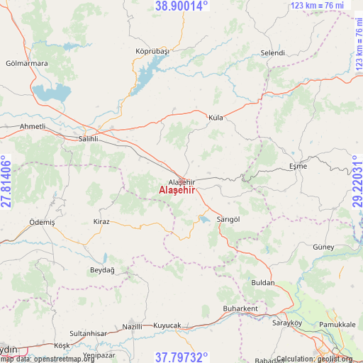
Alaşehir GPS coordinates[2]
38° 21' 2.988" North, 28° 31' 1.848" East
| Map corner | latitude | longitude |
|---|---|---|
| Upper-left | 38.90014°, | 27.81406° |
| Center: | 38.35083°, | 28.51718° |
| Lower-right: | 37.79732°, | 29.22031° |
| Map W x H: | 122.6×122.6 km | = 76.2×76.2mi |
| max Lat: | 42.02683° ⇑55.2% North |
| Alaşehir: | 38.35083° |
| min Lat: | ⇓44.8% South 35.9025° |
| min Long | Alaşehir | max Long |
| 25.90902° | 28.51718° | 44.60099° |
| W 13%⇐ | ⇒87% E |
Elevation
Elevation of Alaşehir is 207 m = 679 ft, and this is 510.4 m = 1675 ft below average elevation for this country.
| Max E: |
2682 m = 8799 ft | 73.3% |
| Avg. | 717.4 m = 2354 ft | |
| Alaşehir | 207 m = 679 ft | |
Min E: |
0 m = 0 ft | 26.7% |
See also: Alaşehir elevation on elevation.city.
Geographical zone
Alaşehir is located in North temperate zone (between Tropic of Cancer and the Arctic Circle). Distance of this Northern Tropic circle is 1658.3 km =1030.4 mi to South.| Distance of | km | miles | from Alaşehir |
|---|---|---|---|
| North Pole | 5742.8 | 3568.4 | to North |
| Arctic Circle | 3137 | 1949.2 | to North |
| Tropic Cancer | 1658.3 | 1030.4 | to South |
| Equator | 4264.2 | 2649.7 | to South |


Nearby cities:
15 places around Alaşehir: (largest is in red/bold)
• Adala
33.2 km =20.6 mi,  319°
319°
• Birgi
41.5 km =25.8 mi,  254°
254°
• Borlu
44.9 km =27.9 mi,  354°
354°
• Buharkent
47.3 km =29.4 mi,  155°
155°
• Buldan
43.7 km =27.2 mi,  141°
141°
• Eşme
39.8 km =24.7 mi,  82°
82°
• Kaymakçı
40.6 km =25.2 mi,  239°
239°
• Kiraz
30.4 km =18.9 mi, 243°
• Kula
24.7 km =15.3 mi,  27°
27°
• Köprübaşı
45.4 km =28.2 mi, 347°
• Menye
25.1 km =15.6 mi, 354°
• Salihli
35.4 km =22 mi,  294°
294°
• Sarıgöl
20 km =12.4 mi,  128°
128°
• Yeşilyurt
12.9 km =8 mi,  95°
95°
• Çaylı
39.3 km =24.4 mi, 236°
Sources, notices
• [Note1] Compared only with cities in Turkey existing in our database
• [Src1] Map data: © OpenStreetMap contributors (CC-BY-SA)
• [Src2] Other city data from geonames.org with taken over terms of usage.
• [Src3] Geographical zone / Annual Mean Temperature by Robert A. Rohde @ Wikipedia
