Salihli geodata
Salihli (Manisa) is a seat of a second-order administrative division; located in Turkey in Europe/Istanbul (GMT+3) time zone. With population of 88,906 people, there are 99 cities with bigger population in this country. Compared to other cities in Turkey, 53.1% of cities are located further ↑North; 89.1% of cities are located further →East and 80.8% of cities have higher elevation than Salihli. Note1


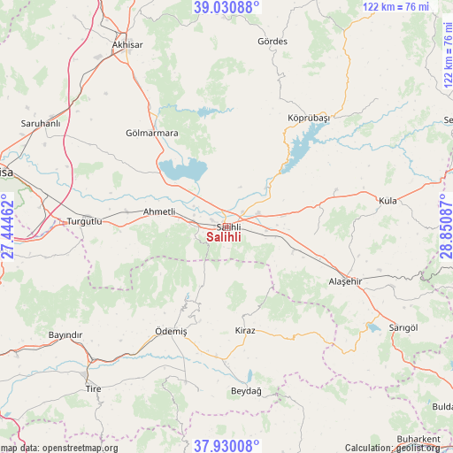
Salihli GPS coordinates[2]
38° 28' 57.288" North, 28° 8' 51.864" East
| Map corner | latitude | longitude |
|---|---|---|
| Upper-left | 39.03088°, | 27.44462° |
| Center: | 38.48258°, | 28.14774° |
| Lower-right: | 37.93008°, | 28.85087° |
| Map W x H: | 122.4×122.4 km | = 76.1×76.1mi |
| max Lat: | 42.02683° ⇑53.1% North |
| Salihli: | 38.48258° |
| min Lat: | ⇓46.9% South 35.9025° |
| min Long | Salihli | max Long |
| 25.90902° | 28.14774° | 44.60099° |
| W 10.9%⇐ | ⇒89.1% E |
Elevation
Elevation of Salihli is 109 m = 358 ft, and this is 608.4 m = 1996 ft below average elevation for this country.
| Max E: |
2682 m = 8799 ft | 80.8% |
| Avg. | 717.4 m = 2354 ft | |
| Salihli | 109 m = 358 ft | |
Min E: |
0 m = 0 ft | 19.2% |
See also: Salihli elevation on elevation.city.
Geographical zone
Salihli is located in North temperate zone (between Tropic of Cancer and the Arctic Circle). Distance of this Northern Tropic circle is 1672.9 km =1039.5 mi to South.| Distance of | km | miles | from Salihli |
|---|---|---|---|
| North Pole | 5728.2 | 3559.3 | to North |
| Arctic Circle | 3122.3 | 1940.1 | to North |
| Tropic Cancer | 1672.9 | 1039.5 | to South |
| Equator | 4278.9 | 2658.8 | to South |


Nearby cities:
15 places around Salihli: (largest is in red/bold)
• Adala
14.9 km =9.3 mi,  44°
44°
• Ahmetli
18.7 km =11.6 mi,  282°
282°
• Alaşehir
35.4 km =22 mi,  114°
114°
• Birgi
27 km =16.8 mi,  196°
196°
• Borlu
40.9 km =25.4 mi, 42°
• Gölmarmara
32.8 km =20.4 mi,  321°
321°
• Kaymakçı
35.1 km =21.8 mi,  184°
184°
• Kiraz
28.5 km =17.7 mi,  169°
169°
• Konaklı
43.2 km =26.8 mi, 197°
• Köprübaşı
37.2 km =23.1 mi, 36°
• Menye
31.4 km =19.5 mi,  70°
70°
• Ovakent
43.2 km =26.8 mi,  194°
194°
• Turgutlu
39 km =24.2 mi,  272°
272°
• Çaylı
36.6 km =22.7 mi, 180°
• Ödemiş
32.3 km =20.1 mi,  208°
208°
Sources, notices
• [Note1] Compared only with cities in Turkey existing in our database
• [Src1] Map data: © OpenStreetMap contributors (CC-BY-SA)
• [Src2] Other city data from geonames.org with taken over terms of usage.
• [Src3] Geographical zone / Annual Mean Temperature by Robert A. Rohde @ Wikipedia
