Gölhisar geodata
Gölhisar (Burdur) is a seat of a second-order administrative division; located in Turkey in Europe/Istanbul (GMT+3) time zone. With population of 12,721 people, there are 437 cities with bigger population in this country. Compared to other cities in Turkey, 85.3% of cities are located further ↑North; 79.5% of cities are located further →East and 68.1% of cities have lower elevation than Gölhisar. Note1


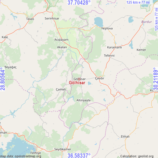
Gölhisar GPS coordinates[2]
37° 8' 45.24" North, 29° 30' 31.536" East
| Map corner | latitude | longitude |
|---|---|---|
| Upper-left | 37.70428°, | 28.80564° |
| Center: | 37.1459°, | 29.50876° |
| Lower-right: | 36.58337°, | 30.21189° |
| Map W x H: | 124.6×124.6 km | = 77.4×77.4mi |
| max Lat: | 42.02683° ⇑85.3% North |
| Gölhisar: | 37.1459° |
| min Lat: | ⇓14.7% South 35.9025° |
| min Long | Gölhisar | max Long |
| 25.90902° | 29.50876° | 44.60099° |
| W 20.5%⇐ | ⇒79.5% E |
Elevation
Elevation of Gölhisar is 1003 m = 3291 ft, and this is 285.6 m = 937 ft above average elevation for this country.
| Max E: |
2682 m = 8799 ft | 31.9% |
| Gölhisar | 1003 m 3291 ft | |
| Avg. | 717.4 m = 2354 ft | |
Min E: |
0 m = 0 ft | 68.1% |
See also: Turkey elevation on elevation.city.
Geographical zone
Gölhisar is located in North temperate zone (between Tropic of Cancer and the Arctic Circle). Distance of this Northern Tropic circle is 1524.3 km =947.2 mi to South.| Distance of | km | miles | from Gölhisar |
|---|---|---|---|
| North Pole | 5876.8 | 3651.7 | to North |
| Arctic Circle | 3270.9 | 2032.4 | to North |
| Tropic Cancer | 1524.3 | 947.2 | to South |
| Equator | 4130.2 | 2566.4 | to South |


Nearby cities:
15 places around Gölhisar: (largest is in red/bold)
• Acıpayam
34 km =21.1 mi,  335°
335°
• Altınyayla
16.9 km =10.5 mi,  168°
168°
• Karamanlı
37.6 km =23.4 mi,  47°
47°
• Kelekçi
21 km =13 mi,  300°
300°
• Kemer
54.2 km =33.7 mi,  64°
64°
• Kızılcadağ
42.8 km =26.6 mi,  109°
109°
• Kızılyaka
18.2 km =11.3 mi, 174°
• Nikfer
43.7 km =27.2 mi,  311°
311°
• Seki
40.1 km =24.9 mi,  161°
161°
• Serinhisar
52.9 km =32.9 mi, 336°
• Tefenni
29.8 km =18.5 mi, 52°
• Yeşilova
45.8 km =28.5 mi,  28°
28°
• Yeşilüzümlü
52 km =32.3 mi,  208°
208°
• Çameli
16.5 km =10.3 mi,  241°
241°
• Çavdır
16.4 km =10.2 mi,  86°
86°
Sources, notices
• [Note1] Compared only with cities in Turkey existing in our database
• [Src1] Map data: © OpenStreetMap contributors (CC-BY-SA)
• [Src2] Other city data from geonames.org with taken over terms of usage.
• [Src3] Geographical zone / Annual Mean Temperature by Robert A. Rohde @ Wikipedia
