Keles geodata
Keles (Bursa) is a seat of a second-order administrative division; located in Turkey in Europe/Istanbul (GMT+3) time zone. With population of 3,772 people, there are 801 cities with bigger population in this country. Compared to other cities in Turkey, 67.6% of cities are located further ↓South; 81.6% of cities are located further →East and 69.7% of cities have lower elevation than Keles. Note1


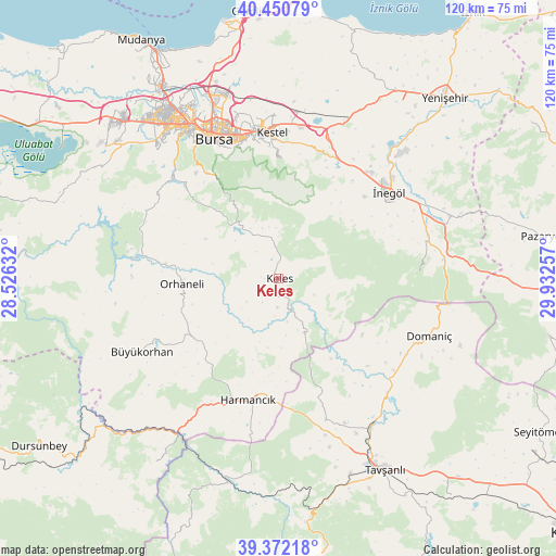
Keles GPS coordinates[2]
39° 54' 48.996" North, 29° 13' 45.984" East
| Map corner | latitude | longitude |
|---|---|---|
| Upper-left | 40.45079°, | 28.52632° |
| Center: | 39.91361°, | 29.22944° |
| Lower-right: | 39.37218°, | 29.93257° |
| Map W x H: | 119.9×119.9 km | = 74.5×74.5mi |
| max Lat: | 42.02683° ⇑32.4% North |
| Keles: | 39.91361° |
| min Lat: | ⇓67.6% South 35.9025° |
| min Long | Keles | max Long |
| 25.90902° | 29.22944° | 44.60099° |
| W 18.4%⇐ | ⇒81.6% E |
Elevation
Elevation of Keles is 1024 m = 3360 ft, and this is 306.6 m = 1006 ft above average elevation for this country.
| Max E: |
2682 m = 8799 ft | 30.3% |
| Keles | 1024 m 3360 ft | |
| Avg. | 717.4 m = 2354 ft | |
Min E: |
0 m = 0 ft | 69.7% |
See also: Turkey elevation on elevation.city.
Geographical zone
Keles is located in North temperate zone (between Tropic of Cancer and the Arctic Circle). Distance of this Northern Tropic circle is 1832.1 km =1138.4 mi to South.| Distance of | km | miles | from Keles |
|---|---|---|---|
| North Pole | 5569.1 | 3460.5 | to North |
| Arctic Circle | 2963.2 | 1841.2 | to North |
| Tropic Cancer | 1832.1 | 1138.4 | to South |
| Equator | 4438 | 2757.6 | to South |


Nearby cities:
15 places around Keles: (largest is in red/bold)
• Alanyurt
32.8 km =20.4 mi,  48°
48°
• Büyükorhan
33.3 km =20.7 mi,  241°
241°
• Cerrah
25.5 km =15.8 mi, 46°
• Gürsu
34.1 km =21.2 mi,  355°
355°
• Harmancık
27.2 km =16.9 mi,  193°
193°
• Karıncalı
32.2 km =20 mi,  281°
281°
• Kestel
31.7 km =19.7 mi, 357°
• Kirazlı
26.1 km =16.2 mi,  322°
322°
• Kozluören
25.9 km =16.1 mi,  23°
23°
• Orhaneli
20.4 km =12.7 mi,  266°
266°
• Soğukpınar
18.1 km =11.2 mi,  329°
329°
• Yenice
25.4 km =15.8 mi,  40°
40°
• Yenice
32.3 km =20.1 mi, 238°
• Yıldırım
32.2 km =20 mi,  341°
341°
• İnegol
30.3 km =18.8 mi, 52°
Sources, notices
• [Note1] Compared only with cities in Turkey existing in our database
• [Src1] Map data: © OpenStreetMap contributors (CC-BY-SA)
• [Src2] Other city data from geonames.org with taken over terms of usage.
• [Src3] Geographical zone / Annual Mean Temperature by Robert A. Rohde @ Wikipedia
