Büyükorhan geodata
Büyükorhan (Bursa) is a seat of a second-order administrative division; located in Turkey in Europe/Istanbul (GMT+3) time zone. In our database, there are 1323 cities with bigger population. Compared to other cities in Turkey, 65% of cities are located further ↓South; 84.8% of cities are located further →East and 55.7% of cities have lower elevation than Büyükorhan. Note1


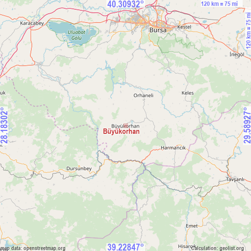
Büyükorhan GPS coordinates[2]
39° 46' 15.672" North, 28° 53' 10.104" East
| Map corner | latitude | longitude |
|---|---|---|
| Upper-left | 40.30932°, | 28.18302° |
| Center: | 39.77102°, | 28.88614° |
| Lower-right: | 39.22847°, | 29.58927° |
| Map W x H: | 120.2×120.2 km | = 74.7×74.7mi |
| max Lat: | 42.02683° ⇑35% North |
| Büyükorhan: | 39.77102° |
| min Lat: | ⇓65% South 35.9025° |
| min Long | Büyükorhan | max Long |
| 25.90902° | 28.88614° | 44.60099° |
| W 15.2%⇐ | ⇒84.8% E |
Elevation
Elevation of Büyükorhan is 804 m = 2638 ft, and this is 86.6 m = 284 ft above average elevation for this country.
| Max E: |
2682 m = 8799 ft | 44.3% |
| Büyükorhan | 804 m 2638 ft | |
| Avg. | 717.4 m = 2354 ft | |
Min E: |
0 m = 0 ft | 55.7% |
See also: Turkey elevation on elevation.city.
Geographical zone
Büyükorhan is located in North temperate zone (between Tropic of Cancer and the Arctic Circle). Distance of this Northern Tropic circle is 1816.2 km =1128.5 mi to South.| Distance of | km | miles | from Büyükorhan |
|---|---|---|---|
| North Pole | 5584.9 | 3470.3 | to North |
| Arctic Circle | 2979.1 | 1851.1 | to North |
| Tropic Cancer | 1816.2 | 1128.5 | to South |
| Equator | 4422.1 | 2747.8 | to South |


Nearby cities:
15 places around Büyükorhan: (largest is in red/bold)
• Dağardı
39 km =24.2 mi,  166°
166°
• Devecikonağı
32 km =19.9 mi,  300°
300°
• Dursunbey
30.3 km =18.8 mi,  227°
227°
• Gökçedağ
23.8 km =14.8 mi, 173°
• Harmancık
25.3 km =15.7 mi,  114°
114°
• Karıncalı
22.4 km =13.9 mi,  354°
354°
• Kavacık
35.1 km =21.8 mi,  252°
252°
• Keles
33.3 km =20.7 mi,  61°
61°
• Kirazlı
38.9 km =24.2 mi,  19°
19°
• Orhaneli
17.2 km =10.7 mi,  31°
31°
• Soldere
41.9 km =26 mi,  320°
320°
• Soğukpınar
37.4 km =23.2 mi, 32°
• Yenice
2.1 km =1.3 mi,  121°
121°
• Çaltılıbük
32 km =19.9 mi,  310°
310°
• Çalı
44.3 km =27.5 mi,  3°
3°
Sources, notices
• [Note1] Compared only with cities in Turkey existing in our database
• [Src1] Map data: © OpenStreetMap contributors (CC-BY-SA)
• [Src2] Other city data from geonames.org with taken over terms of usage.
• [Src3] Geographical zone / Annual Mean Temperature by Robert A. Rohde @ Wikipedia
