Yenice geodata
Yenice (Bursa) is a populated place; located in Turkey in Europe/Istanbul (GMT+3) time zone. With population of 3,708 people, there are 806 cities with bigger population in this country. Compared to other cities in Turkey, 64.9% of cities are located further ↓South; 84.6% of cities are located further →East and 53.8% of cities have lower elevation than Yenice. Note1


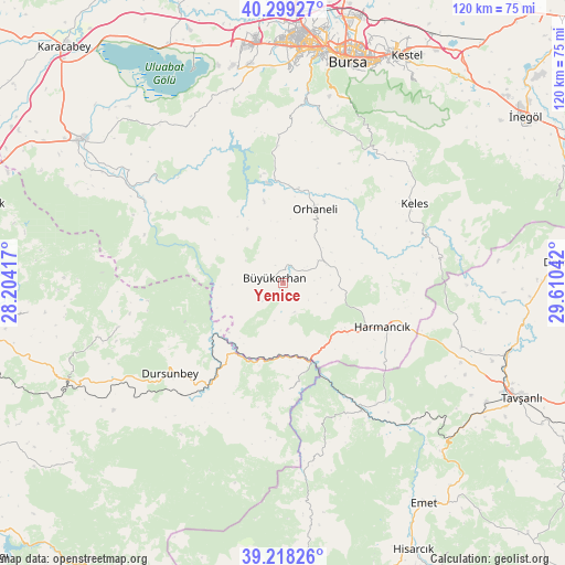
Yenice GPS coordinates[2]
39° 45' 39.204" North, 28° 54' 26.244" East
| Map corner | latitude | longitude |
|---|---|---|
| Upper-left | 40.29927°, | 28.20417° |
| Center: | 39.76089°, | 28.90729° |
| Lower-right: | 39.21826°, | 29.61042° |
| Map W x H: | 120.2×120.2 km | = 74.7×74.7mi |
| max Lat: | 42.02683° ⇑35.1% North |
| Yenice: | 39.76089° |
| min Lat: | ⇓64.9% South 35.9025° |
| min Long | Yenice | max Long |
| 25.90902° | 28.90729° | 44.60099° |
| W 15.4%⇐ | ⇒84.6% E |
Elevation
Elevation of Yenice is 769 m = 2523 ft, and this is 51.6 m = 169 ft above average elevation for this country.
| Max E: |
2682 m = 8799 ft | 46.2% |
| Yenice | 769 m 2523 ft | |
| Avg. | 717.4 m = 2354 ft | |
Min E: |
0 m = 0 ft | 53.8% |
See also: Turkey elevation on elevation.city.
Geographical zone
Yenice is located in North temperate zone (between Tropic of Cancer and the Arctic Circle). Distance of this Northern Tropic circle is 1815.1 km =1127.9 mi to South.| Distance of | km | miles | from Yenice |
|---|---|---|---|
| North Pole | 5586.1 | 3471 | to North |
| Arctic Circle | 2980.2 | 1851.8 | to North |
| Tropic Cancer | 1815.1 | 1127.9 | to South |
| Equator | 4421 | 2747.1 | to South |


Nearby cities:
15 places around Yenice: (largest is in red/bold)
• Büyükorhan
2.1 km =1.3 mi,  301°
301°
• Dağardı
37.5 km =23.3 mi,  168°
168°
• Devecikonağı
34.1 km =21.2 mi, 300°
• Dursunbey
31 km =19.3 mi,  231°
231°
• Gökçedağ
22.5 km =14 mi,  177°
177°
• Harmancık
23.2 km =14.4 mi,  113°
113°
• Karıncalı
23.7 km =14.7 mi,  349°
349°
• Kavacık
36.6 km =22.7 mi,  254°
254°
• Keles
32.3 km =20.1 mi,  58°
58°
• Kirazlı
39.4 km =24.5 mi,  16°
16°
• Orhaneli
17.4 km =10.8 mi, 24°
• Soldere
43.9 km =27.3 mi,  319°
319°
• Soğukpınar
37.5 km =23.3 mi,  29°
29°
• Çaltılıbük
34.1 km =21.2 mi,  309°
309°
• Çalı
45.3 km =28.1 mi,  1°
1°
Sources, notices
• [Note1] Compared only with cities in Turkey existing in our database
• [Src1] Map data: © OpenStreetMap contributors (CC-BY-SA)
• [Src2] Other city data from geonames.org with taken over terms of usage.
• [Src3] Geographical zone / Annual Mean Temperature by Robert A. Rohde @ Wikipedia
