Kestel geodata
Kestel (Bursa) is a seat of a second-order administrative division; located in Turkey in Europe/Istanbul (GMT+3) time zone. With population of 36,185 people, there are 219 cities with bigger population in this country. Compared to other cities in Turkey, 72.5% of cities are located further ↓South; 81.8% of cities are located further →East and 79% of cities have higher elevation than Kestel. Note1


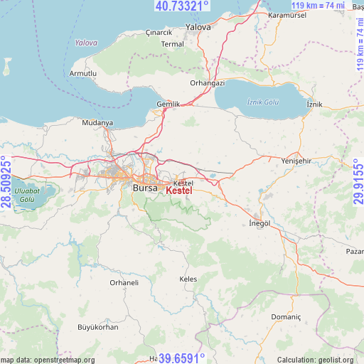
Kestel GPS coordinates[2]
40° 11' 53.808" North, 29° 12' 44.532" East
| Map corner | latitude | longitude |
|---|---|---|
| Upper-left | 40.73321°, | 28.50925° |
| Center: | 40.19828°, | 29.21237° |
| Lower-right: | 39.6591°, | 29.9155° |
| Map W x H: | 119.4×119.4 km | = 74.2×74.2mi |
| max Lat: | 42.02683° ⇑27.5% North |
| Kestel: | 40.19828° |
| min Lat: | ⇓72.5% South 35.9025° |
| min Long | Kestel | max Long |
| 25.90902° | 29.21237° | 44.60099° |
| W 18.2%⇐ | ⇒81.8% E |
Elevation
Elevation of Kestel is 122 m = 400 ft, and this is 595.4 m = 1953 ft below average elevation for this country.
| Max E: |
2682 m = 8799 ft | 79% |
| Avg. | 717.4 m = 2354 ft | |
| Kestel | 122 m = 400 ft | |
Min E: |
0 m = 0 ft | 21% |
See also: Turkey elevation on elevation.city.
Geographical zone
Kestel is located in North temperate zone (between Tropic of Cancer and the Arctic Circle). Distance of this Northern Tropic circle is 1863.7 km =1158 mi to South.| Distance of | km | miles | from Kestel |
|---|---|---|---|
| North Pole | 5537.4 | 3440.8 | to North |
| Arctic Circle | 2931.5 | 1821.5 | to North |
| Tropic Cancer | 1863.7 | 1158 | to South |
| Equator | 4469.6 | 2777.3 | to South |


Nearby cities:
15 places around Kestel: (largest is in red/bold)
• Bursa
12.9 km =8 mi,  268°
268°
• Cerrah
24.4 km =15.2 mi,  125°
125°
• Demirtaş
12.7 km =7.9 mi,  310°
310°
• Gölcük
16.5 km =10.3 mi,  58°
58°
• Gürsu
2.7 km =1.7 mi,  326°
326°
• Kirazlı
18.2 km =11.3 mi,  232°
232°
• Kozluören
14.4 km =8.9 mi,  123°
123°
• Nilüfer
25.3 km =15.7 mi, 273°
• Osmangazi
13 km =8.1 mi, 269°
• Seçköy
14 km =8.7 mi,  354°
354°
• Soğukpınar
17.7 km =11 mi,  205°
205°
• Umurbey
24.2 km =15 mi, 354°
• Yenice
21.6 km =13.4 mi, 124°
• Yıldırım
8.8 km =5.5 mi,  262°
262°
• Çalı
25 km =15.5 mi, 262°
Sources, notices
• [Note1] Compared only with cities in Turkey existing in our database
• [Src1] Map data: © OpenStreetMap contributors (CC-BY-SA)
• [Src2] Other city data from geonames.org with taken over terms of usage.
• [Src3] Geographical zone / Annual Mean Temperature by Robert A. Rohde @ Wikipedia
