İnegol geodata
İnegol (Bursa) is a seat of a second-order administrative division; located in Turkey in Europe/Istanbul (GMT+3) time zone. With population of 133,959 people, there are 66 cities with bigger population in this country. Compared to other cities in Turkey, 70.5% of cities are located further ↓South; 79.4% of cities are located further →East and 70.2% of cities have higher elevation than İnegol. Note1


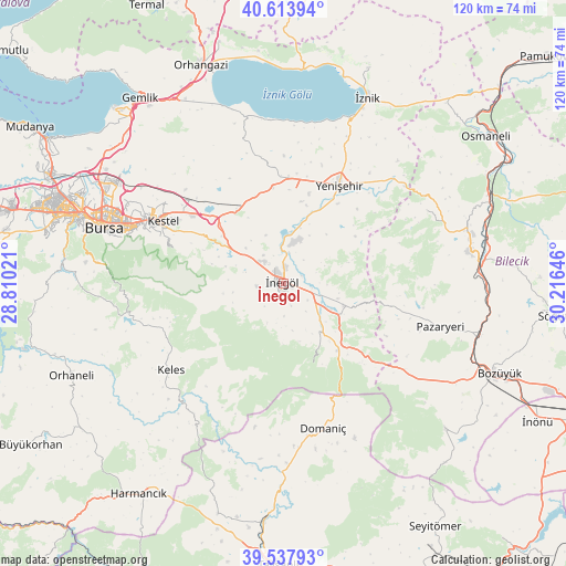
İnegol GPS coordinates[2]
40° 4' 41.016" North, 29° 30' 47.988" East
| Map corner | latitude | longitude |
|---|---|---|
| Upper-left | 40.61394°, | 28.81021° |
| Center: | 40.07806°, | 29.51333° |
| Lower-right: | 39.53793°, | 30.21646° |
| Map W x H: | 119.6×119.6 km | = 74.3×74.3mi |
| max Lat: | 42.02683° ⇑29.5% North |
| İnegol: | 40.07806° |
| min Lat: | ⇓70.5% South 35.9025° |
| min Long | İnegol | max Long |
| 25.90902° | 29.51333° | 44.60099° |
| W 20.6%⇐ | ⇒79.4% E |
Elevation
Elevation of İnegol is 293 m = 961 ft, and this is 424.4 m = 1392 ft below average elevation for this country.
| Max E: |
2682 m = 8799 ft | 70.2% |
| Avg. | 717.4 m = 2354 ft | |
| İnegol | 293 m = 961 ft | |
Min E: |
0 m = 0 ft | 29.8% |
See also: İnegol elevation on elevation.city.
Geographical zone
İnegol is located in North temperate zone (between Tropic of Cancer and the Arctic Circle). Distance of this Northern Tropic circle is 1850.3 km =1149.7 mi to South.| Distance of | km | miles | from İnegol |
|---|---|---|---|
| North Pole | 5550.8 | 3449.1 | to North |
| Arctic Circle | 2944.9 | 1829.9 | to North |
| Tropic Cancer | 1850.3 | 1149.7 | to South |
| Equator | 4456.3 | 2769 | to South |


Nearby cities:
15 places around İnegol: (largest is in red/bold)
• Alanyurt
3.4 km =2.1 mi,  7°
7°
• Balarim
33.5 km =20.8 mi, 11°
• Cerrah
5.7 km =3.5 mi,  262°
262°
• Domaniç
31.8 km =19.8 mi,  165°
165°
• Gölcük
24.9 km =15.5 mi,  332°
332°
• Gürsu
31.3 km =19.4 mi,  300°
300°
• Hamzabey
6.5 km =4 mi, 9°
• Keles
30.3 km =18.8 mi,  232°
232°
• Kestel
28.9 km =18 mi, 297°
• Kozluören
14.7 km =9.1 mi,  291°
291°
• Kurşunlu
13.3 km =8.3 mi,  110°
110°
• Soğukpınar
33.3 km =20.7 mi,  265°
265°
• Tahtaköprü
18.4 km =11.4 mi,  140°
140°
• Yenice
7.8 km =4.8 mi,  277°
277°
• Yenişehir
23.9 km =14.9 mi,  29°
29°
Sources, notices
• [Note1] Compared only with cities in Turkey existing in our database
• [Src1] Map data: © OpenStreetMap contributors (CC-BY-SA)
• [Src2] Other city data from geonames.org with taken over terms of usage.
• [Src3] Geographical zone / Annual Mean Temperature by Robert A. Rohde @ Wikipedia
