Karşıyaka geodata
Karşıyaka (İzmir) is a seat of a second-order administrative division; located in Turkey in Europe/Istanbul (GMT+3) time zone. In our database, there are 1323 cities with bigger population. Compared to other cities in Turkey, 53.5% of cities are located further ↑North; 96.3% of cities are located further →East and 97.8% of cities have higher elevation than Karşıyaka. Note1


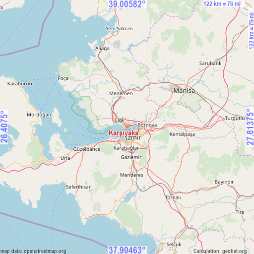
Karşıyaka GPS coordinates[2]
38° 27' 26.388" North, 27° 6' 38.232" East
| Map corner | latitude | longitude |
|---|---|---|
| Upper-left | 39.00582°, | 26.4075° |
| Center: | 38.45733°, | 27.11062° |
| Lower-right: | 37.90463°, | 27.81375° |
| Map W x H: | 122.4×122.4 km | = 76.1×76.1mi |
| max Lat: | 42.02683° ⇑53.5% North |
| Karşıyaka: | 38.45733° |
| min Lat: | ⇓46.5% South 35.9025° |
| min Long | Karşıyaka | max Long |
| 25.90902° | 27.11062° | 44.60099° |
| W 3.7%⇐ | ⇒96.3% E |
Elevation
Elevation of Karşıyaka is 10 m = 33 ft, and this is 707.4 m = 2321 ft below average elevation for this country.
| Max E: |
2682 m = 8799 ft | 97.8% |
| Avg. | 717.4 m = 2354 ft | |
| Karşıyaka | 10 m = 33 ft | |
Min E: |
0 m = 0 ft | 2.2% |
See also: Turkey elevation on elevation.city.
Geographical zone
Karşıyaka is located in North temperate zone (between Tropic of Cancer and the Arctic Circle). Distance of this Northern Tropic circle is 1670.1 km =1037.8 mi to South.| Distance of | km | miles | from Karşıyaka |
|---|---|---|---|
| North Pole | 5731 | 3561.1 | to North |
| Arctic Circle | 3125.1 | 1941.8 | to North |
| Tropic Cancer | 1670.1 | 1037.8 | to South |
| Equator | 4276.1 | 2657 | to South |


Nearby cities:
15 places around Karşıyaka: (largest is in red/bold)
• Bayraklı
4.8 km =3 mi,  76°
76°
• Bornova
11.5 km =7.1 mi, 77°
• Buca
8.2 km =5.1 mi,  143°
143°
• Dağkızılca
29.3 km =18.2 mi,  123°
123°
• Emiralem
17.2 km =10.7 mi,  10°
10°
• Gaziemir
14.9 km =9.3 mi,  173°
173°
• Karabağlar
9.5 km =5.9 mi, 166°
• Kemalpaşa
26.9 km =16.7 mi,  97°
97°
• Manisa
32.4 km =20.1 mi,  57°
57°
• Menderes
23.2 km =14.4 mi, 174°
• Menemen
17.1 km =10.6 mi,  347°
347°
• Muradiye
30 km =18.6 mi,  41°
41°
• Osmancalı
36.1 km =22.4 mi,  20°
20°
• Urla
33.7 km =20.9 mi,  243°
243°
• İzmir
5.5 km =3.4 mi,  154°
154°
Sources, notices
• [Note1] Compared only with cities in Turkey existing in our database
• [Src1] Map data: © OpenStreetMap contributors (CC-BY-SA)
• [Src2] Other city data from geonames.org with taken over terms of usage.
• [Src3] Geographical zone / Annual Mean Temperature by Robert A. Rohde @ Wikipedia
