Muradiye geodata
Muradiye (Manisa) is a seat of a third-order administrative division; located in Turkey in Europe/Istanbul (GMT+3) time zone. In our database, there are 1323 cities with bigger population. Compared to other cities in Turkey, 50.6% of cities are located further ↑North; 94.7% of cities are located further →East and 91.8% of cities have higher elevation than Muradiye. Note1


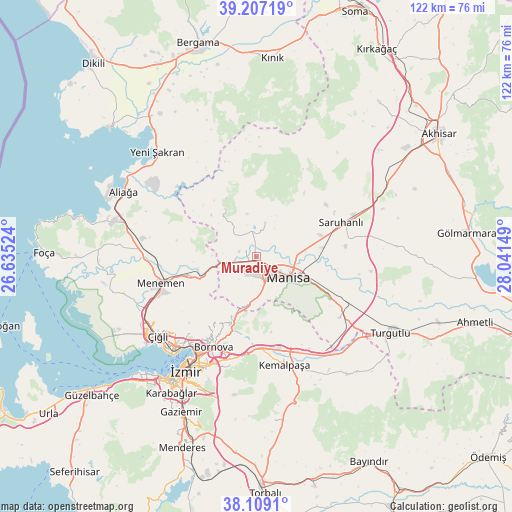
Muradiye GPS coordinates[2]
38° 39' 36.9" North, 27° 20' 18.096" East
| Map corner | latitude | longitude |
|---|---|---|
| Upper-left | 39.20719°, | 26.63524° |
| Center: | 38.66025°, | 27.33836° |
| Lower-right: | 38.1091°, | 28.04149° |
| Map W x H: | 122.1×122.1 km | = 75.9×75.9mi |
| max Lat: | 42.02683° ⇑50.6% North |
| Muradiye: | 38.66025° |
| min Lat: | ⇓49.4% South 35.9025° |
| min Long | Muradiye | max Long |
| 25.90902° | 27.33836° | 44.60099° |
| W 5.3%⇐ | ⇒94.7% E |
Elevation
Elevation of Muradiye is 30 m = 98 ft, and this is 687.4 m = 2255 ft below average elevation for this country.
| Max E: |
2682 m = 8799 ft | 91.8% |
| Avg. | 717.4 m = 2354 ft | |
| Muradiye | 30 m = 98 ft | |
Min E: |
0 m = 0 ft | 8.2% |
See also: Turkey elevation on elevation.city.
Geographical zone
Muradiye is located in North temperate zone (between Tropic of Cancer and the Arctic Circle). Distance of this Northern Tropic circle is 1692.7 km =1051.8 mi to South.| Distance of | km | miles | from Muradiye |
|---|---|---|---|
| North Pole | 5708.4 | 3547 | to North |
| Arctic Circle | 3102.6 | 1927.9 | to North |
| Tropic Cancer | 1692.7 | 1051.8 | to South |
| Equator | 4298.6 | 2671 | to South |


Nearby cities:
15 places around Muradiye: (largest is in red/bold)
• Bayraklı
26.3 km =16.3 mi,  215°
215°
• Bornova
21.9 km =13.6 mi,  203°
203°
• Buca
32.7 km =20.3 mi,  207°
207°
• Emiralem
17.6 km =10.9 mi,  251°
251°
• Halitpaşa
29.6 km =18.4 mi,  84°
84°
• Karaoğlanlı
24.6 km =15.3 mi,  126°
126°
• Karşıyaka
30 km =18.6 mi, 221°
• Kemalpaşa
26.9 km =16.7 mi,  165°
165°
• Manisa
9.3 km =5.8 mi, 125°
• Menemen
24.1 km =15 mi,  255°
255°
• Osmancalı
13.6 km =8.5 mi,  326°
326°
• Saruhanlı
21.6 km =13.4 mi,  67°
67°
• Yuntdağ
32.1 km =19.9 mi,  340°
340°
• Üçpınar
8.5 km =5.3 mi,  13°
13°
• İzmir
32.6 km =20.3 mi, 212°
Sources, notices
• [Note1] Compared only with cities in Turkey existing in our database
• [Src1] Map data: © OpenStreetMap contributors (CC-BY-SA)
• [Src2] Other city data from geonames.org with taken over terms of usage.
• [Src3] Geographical zone / Annual Mean Temperature by Robert A. Rohde @ Wikipedia
