Urla geodata
Urla (İzmir) is a seat of a second-order administrative division; located in Turkey in Europe/Istanbul (GMT+3) time zone. With population of 45,199 people, there are 189 cities with bigger population in this country. Compared to other cities in Turkey, 55.9% of cities are located further ↑North; 98.1% of cities are located further →East and 85.6% of cities have higher elevation than Urla. Note1


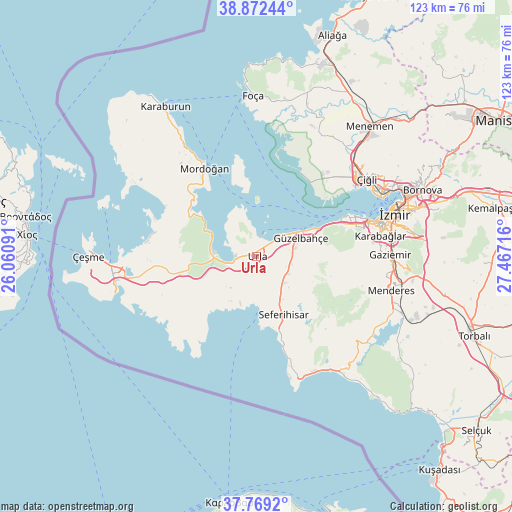
Urla GPS coordinates[2]
38° 19' 22.512" North, 26° 45' 50.508" East
| Map corner | latitude | longitude |
|---|---|---|
| Upper-left | 38.87244°, | 26.06091° |
| Center: | 38.32292°, | 26.76403° |
| Lower-right: | 37.7692°, | 27.46716° |
| Map W x H: | 122.7×122.7 km | = 76.2×76.2mi |
| max Lat: | 42.02683° ⇑55.9% North |
| Urla: | 38.32292° |
| min Lat: | ⇓44.1% South 35.9025° |
| min Long | Urla | max Long |
| 25.90902° | 26.76403° | 44.60099° |
| W 1.9%⇐ | ⇒98.1% E |
Elevation
Elevation of Urla is 67 m = 220 ft, and this is 650.4 m = 2134 ft below average elevation for this country.
| Max E: |
2682 m = 8799 ft | 85.6% |
| Avg. | 717.4 m = 2354 ft | |
| Urla | 67 m = 220 ft | |
Min E: |
0 m = 0 ft | 14.4% |
See also: Urla elevation on elevation.city.
Geographical zone
Urla is located in North temperate zone (between Tropic of Cancer and the Arctic Circle). Distance of this Northern Tropic circle is 1655.2 km =1028.5 mi to South.| Distance of | km | miles | from Urla |
|---|---|---|---|
| North Pole | 5746 | 3570.4 | to North |
| Arctic Circle | 3140.1 | 1951.2 | to North |
| Tropic Cancer | 1655.2 | 1028.5 | to South |
| Equator | 4261.1 | 2647.7 | to South |


Nearby cities:
15 places around Urla: (largest is in red/bold)
• Alaçatı
34.3 km =21.3 mi,  262°
262°
• Bayraklı
38.4 km =23.9 mi,  65°
65°
• Buca
36.1 km =22.4 mi,  76°
76°
• Değirmendere
40.4 km =25.1 mi,  125°
125°
• Foça
38.6 km =24 mi,  359°
359°
• Gaziemir
31.9 km =19.8 mi,  89°
89°
• Karabağlar
32.9 km =20.4 mi, 80°
• Karaburun
41.2 km =25.6 mi,  327°
327°
• Karşıyaka
33.7 km =20.9 mi,  63°
63°
• Menderes
33.3 km =20.7 mi,  104°
104°
• Mordoğan
24.7 km =15.3 mi, 330°
• Seferihisar
15.4 km =9.6 mi,  154°
154°
• Uzunkuyu
19.9 km =12.4 mi, 255°
• Çeşme
40 km =24.9 mi,  270°
270°
• İzmir
34.1 km =21.2 mi, 72°
Sources, notices
• [Note1] Compared only with cities in Turkey existing in our database
• [Src1] Map data: © OpenStreetMap contributors (CC-BY-SA)
• [Src2] Other city data from geonames.org with taken over terms of usage.
• [Src3] Geographical zone / Annual Mean Temperature by Robert A. Rohde @ Wikipedia
