İzmir geodata
İzmir is a seat of a first-order administrative division; located in Turkey in Europe/Istanbul (GMT+3) time zone. With population of 2,500,603 people, there are 2 cities with bigger population in this country. Compared to other cities in Turkey, 54.2% of cities are located further ↑North; 96% of cities are located further →East and 79% of cities have higher elevation than İzmir. Note1


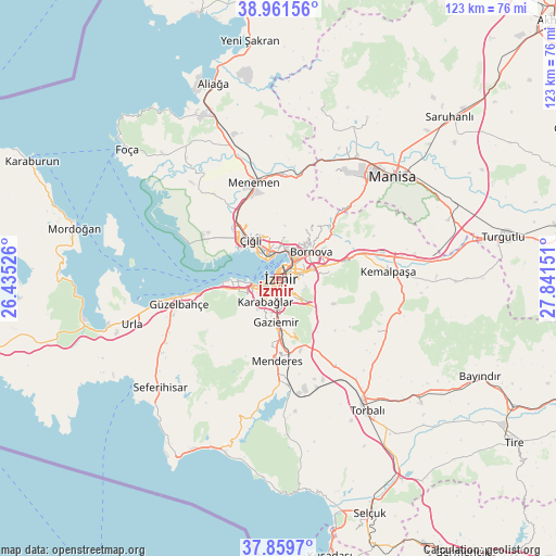
İzmir GPS coordinates[2]
38° 24' 45.828" North, 27° 8' 18.168" East
| Map corner | latitude | longitude |
|---|---|---|
| Upper-left | 38.96156°, | 26.43526° |
| Center: | 38.41273°, | 27.13838° |
| Lower-right: | 37.8597°, | 27.84151° |
| Map W x H: | 122.5×122.5 km | = 76.1×76.1mi |
| max Lat: | 42.02683° ⇑54.2% North |
| İzmir: | 38.41273° |
| min Lat: | ⇓45.8% South 35.9025° |
| min Long | İzmir | max Long |
| 25.90902° | 27.13838° | 44.60099° |
| W 4%⇐ | ⇒96% E |
Elevation
Elevation of İzmir is 122 m = 400 ft, and this is 595.4 m = 1953 ft below average elevation for this country.
| Max E: |
2682 m = 8799 ft | 79% |
| Avg. | 717.4 m = 2354 ft | |
| İzmir | 122 m = 400 ft | |
Min E: |
0 m = 0 ft | 21% |
See also: İzmir elevation on elevation.city.
Geographical zone
İzmir is located in North temperate zone (between Tropic of Cancer and the Arctic Circle). Distance of this Northern Tropic circle is 1665.2 km =1034.7 mi to South.| Distance of | km | miles | from İzmir |
|---|---|---|---|
| North Pole | 5736 | 3564.2 | to North |
| Arctic Circle | 3130.1 | 1945 | to North |
| Tropic Cancer | 1665.2 | 1034.7 | to South |
| Equator | 4271.1 | 2653.9 | to South |


Nearby cities:
15 places around İzmir: (largest is in red/bold)
• Bayraklı
6.4 km =4 mi,  20°
20°
• Bornova
11.5 km =7.1 mi,  50°
50°
• Buca
2.9 km =1.8 mi,  123°
123°
• Dağkızılca
24.7 km =15.3 mi, 117°
• Değirmendere
33.3 km =20.7 mi,  179°
179°
• Emiralem
21.9 km =13.6 mi,  1°
1°
• Gaziemir
9.9 km =6.2 mi, 184°
• Karabağlar
4.3 km =2.7 mi, 183°
• Karşıyaka
5.5 km =3.4 mi,  334°
334°
• Kemalpaşa
24.3 km =15.1 mi,  86°
86°
• Manisa
33.5 km =20.8 mi, 48°
• Menderes
18.1 km =11.2 mi, 181°
• Menemen
22.5 km =14 mi,  344°
344°
• Muradiye
32.6 km =20.3 mi,  32°
32°
• Urla
34.1 km =21.2 mi,  252°
252°
In other languages:
- In Spanish: Esmirna
- In France: Izmir
- In German: Izmir
- In Italian: Smirne
- In Russian: Измир
Sources, notices
• [Note1] Compared only with cities in Turkey existing in our database
• [Src1] Map data: © OpenStreetMap contributors (CC-BY-SA)
• [Src2] Other city data from geonames.org with taken over terms of usage.
• [Src3] Geographical zone / Annual Mean Temperature by Robert A. Rohde @ Wikipedia
