Horsunlu geodata
Horsunlu (Aydın) is a seat of a third-order administrative division; located in Turkey in Europe/Istanbul (GMT+3) time zone. In our database, there are 1323 cities with bigger population. Compared to other cities in Turkey, 64.3% of cities are located further ↑North; 86.5% of cities are located further →East and 80.9% of cities have higher elevation than Horsunlu. Note1


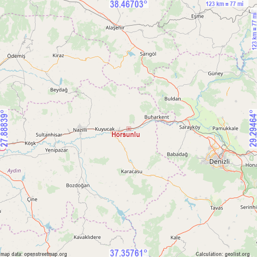
Horsunlu GPS coordinates[2]
37° 54' 51.876" North, 28° 35' 29.436" East
| Map corner | latitude | longitude |
|---|---|---|
| Upper-left | 38.46703°, | 27.88839° |
| Center: | 37.91441°, | 28.59151° |
| Lower-right: | 37.35761°, | 29.29464° |
| Map W x H: | 123.4×123.4 km | = 76.7×76.7mi |
| max Lat: | 42.02683° ⇑64.3% North |
| Horsunlu: | 37.91441° |
| min Lat: | ⇓35.7% South 35.9025° |
| min Long | Horsunlu | max Long |
| 25.90902° | 28.59151° | 44.60099° |
| W 13.5%⇐ | ⇒86.5% E |
Elevation
Elevation of Horsunlu is 108 m = 354 ft, and this is 609.4 m = 1999 ft below average elevation for this country.
| Max E: |
2682 m = 8799 ft | 80.9% |
| Avg. | 717.4 m = 2354 ft | |
| Horsunlu | 108 m = 354 ft | |
Min E: |
0 m = 0 ft | 19.1% |
See also: Turkey elevation on elevation.city.
Geographical zone
Horsunlu is located in North temperate zone (between Tropic of Cancer and the Arctic Circle). Distance of this Northern Tropic circle is 1609.8 km =1000.3 mi to South.| Distance of | km | miles | from Horsunlu |
|---|---|---|---|
| North Pole | 5791.4 | 3598.6 | to North |
| Arctic Circle | 3185.5 | 1979.4 | to North |
| Tropic Cancer | 1609.8 | 1000.3 | to South |
| Equator | 4215.7 | 2619.5 | to South |


Nearby cities:
15 places around Horsunlu: (largest is in red/bold)
• Atça
33.1 km =20.6 mi,  265°
265°
• Babadağ
26.1 km =16.2 mi,  117°
117°
• Bozdoğan
36.4 km =22.6 mi,  222°
222°
• Buharkent
14.4 km =8.9 mi,  67°
67°
• Buldan
25.5 km =15.8 mi,  55°
55°
• Karacasu
20.7 km =12.9 mi,  176°
176°
• Kuyucak
11.6 km =7.2 mi, 269°
• Nazilli
23.6 km =14.7 mi, 270°
• Pamukören
4.5 km =2.8 mi,  282°
282°
• Sarayköy
29.3 km =18.2 mi,  87°
87°
• Sarıgöl
37.3 km =23.2 mi,  14°
14°
• Sultanhisar
38.5 km =23.9 mi, 265°
• Yenice
9.7 km =6 mi,  190°
190°
• Yenipazar
36.2 km =22.5 mi,  253°
253°
• İsabeyli
28.7 km =17.8 mi, 267°
Sources, notices
• [Note1] Compared only with cities in Turkey existing in our database
• [Src1] Map data: © OpenStreetMap contributors (CC-BY-SA)
• [Src2] Other city data from geonames.org with taken over terms of usage.
• [Src3] Geographical zone / Annual Mean Temperature by Robert A. Rohde @ Wikipedia
