Yenice geodata
Yenice (Aydın) is a seat of a third-order administrative division; located in Turkey in Europe/Istanbul (GMT+3) time zone. In our database, there are 1323 cities with bigger population. Compared to other cities in Turkey, 67.7% of cities are located further ↑North; 86.7% of cities are located further →East and 74.5% of cities have higher elevation than Yenice. Note1


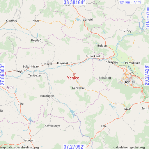
Yenice GPS coordinates[2]
37° 49' 42.132" North, 28° 34' 16.14" East
| Map corner | latitude | longitude |
|---|---|---|
| Upper-left | 38.38164°, | 27.86803° |
| Center: | 37.82837°, | 28.57115° |
| Lower-right: | 37.27092°, | 29.27428° |
| Map W x H: | 123.5×123.5 km | = 76.7×76.7mi |
| max Lat: | 42.02683° ⇑67.7% North |
| Yenice: | 37.82837° |
| min Lat: | ⇓32.3% South 35.9025° |
| min Long | Yenice | max Long |
| 25.90902° | 28.57115° | 44.60099° |
| W 13.3%⇐ | ⇒86.7% E |
Elevation
Elevation of Yenice is 184 m = 604 ft, and this is 533.4 m = 1750 ft below average elevation for this country.
| Max E: |
2682 m = 8799 ft | 74.5% |
| Avg. | 717.4 m = 2354 ft | |
| Yenice | 184 m = 604 ft | |
Min E: |
0 m = 0 ft | 25.5% |
See also: Turkey elevation on elevation.city.
Geographical zone
Yenice is located in North temperate zone (between Tropic of Cancer and the Arctic Circle). Distance of this Northern Tropic circle is 1600.2 km =994.3 mi to South.| Distance of | km | miles | from Yenice |
|---|---|---|---|
| North Pole | 5800.9 | 3604.5 | to North |
| Arctic Circle | 3195.1 | 1985.3 | to North |
| Tropic Cancer | 1600.2 | 994.3 | to South |
| Equator | 4206.1 | 2613.5 | to South |


Nearby cities:
15 places around Yenice: (largest is in red/bold)
• Atça
32 km =19.9 mi,  282°
282°
• Babadağ
25.2 km =15.7 mi,  95°
95°
• Bozdoğan
28.6 km =17.8 mi,  232°
232°
• Buharkent
21.3 km =13.2 mi,  44°
44°
• Buldan
33.1 km =20.6 mi, 43°
• Horsunlu
9.7 km =6 mi,  10°
10°
• Karacasu
11.5 km =7.1 mi,  164°
164°
• Kuyucak
13.6 km =8.5 mi,  313°
313°
• Merkezefendi
41.5 km =25.8 mi,  93°
93°
• Nazilli
23.9 km =14.9 mi,  294°
294°
• Pamukören
10.9 km =6.8 mi,  346°
346°
• Sarayköy
32.9 km =20.4 mi,  71°
71°
• Sultanhisar
37.2 km =23.1 mi, 280°
• Yenipazar
33 km =20.5 mi,  269°
269°
• İsabeyli
28.1 km =17.5 mi, 286°
Sources, notices
• [Note1] Compared only with cities in Turkey existing in our database
• [Src1] Map data: © OpenStreetMap contributors (CC-BY-SA)
• [Src2] Other city data from geonames.org with taken over terms of usage.
• [Src3] Geographical zone / Annual Mean Temperature by Robert A. Rohde @ Wikipedia
