İliç geodata
İliç (Erzincan) is a seat of a second-order administrative division; located in Turkey in Europe/Istanbul (GMT+3) time zone. With population of 2,151 people, there are 932 cities with bigger population in this country. Compared to other cities in Turkey, 60.7% of cities are located further ↓South; 64.5% of cities are located further ←West and 72.9% of cities have lower elevation than İliç. Note1


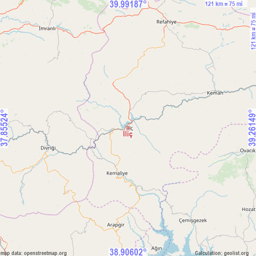
İliç GPS coordinates[2]
39° 27' 3.816" North, 38° 33' 30.096" East
| Map corner | latitude | longitude |
|---|---|---|
| Upper-left | 39.99187°, | 37.85524° |
| Center: | 39.45106°, | 38.55836° |
| Lower-right: | 38.90602°, | 39.26149° |
| Map W x H: | 120.7×120.7 km | = 75×75mi |
| max Lat: | 42.02683° ⇑39.3% North |
| İliç: | 39.45106° |
| min Lat: | ⇓60.7% South 35.9025° |
| min Long | İliç | max Long |
| 25.90902° | 38.55836° | 44.60099° |
| W 64.5%⇐ | ⇒35.5% E |
Elevation
Elevation of İliç is 1069 m = 3507 ft, and this is 351.6 m = 1154 ft above average elevation for this country.
| Max E: |
2682 m = 8799 ft | 27.1% |
| İliç | 1069 m 3507 ft | |
| Avg. | 717.4 m = 2354 ft | |
Min E: |
0 m = 0 ft | 72.9% |
See also: Turkey elevation on elevation.city.
Geographical zone
İliç is located in North temperate zone (between Tropic of Cancer and the Arctic Circle). Distance of this Northern Tropic circle is 1780.6 km =1106.4 mi to South.| Distance of | km | miles | from İliç |
|---|---|---|---|
| North Pole | 5620.5 | 3492.4 | to North |
| Arctic Circle | 3014.6 | 1873.2 | to North |
| Tropic Cancer | 1780.6 | 1106.4 | to South |
| Equator | 4386.5 | 2725.6 | to South |


Nearby cities:
15 places around İliç: (largest is in red/bold)
• Arapgir
45.9 km =28.5 mi,  186°
186°
• Armutlu
17.8 km =11.1 mi,  320°
320°
• Başpınar
31.1 km =19.3 mi,  159°
159°
• Bozoğlak
28.3 km =17.6 mi,  47°
47°
• Cengerli
45.5 km =28.3 mi,  33°
33°
• Danişment
43.9 km =27.3 mi,  224°
224°
• Divriği
39.2 km =24.4 mi,  256°
256°
• Dutluca
35.3 km =21.9 mi,  173°
173°
• Gedikbaşı
27 km =16.8 mi,  279°
279°
• Gedikler
46.1 km =28.6 mi,  152°
152°
• Gümüşakar
39.4 km =24.5 mi,  14°
14°
• Kemah
43 km =26.7 mi,  67°
67°
• Kemaliye
21.6 km =13.4 mi, 194°
• Kuruçay
22.2 km =13.8 mi,  341°
341°
• Oğuz
28.6 km =17.8 mi,  77°
77°
Sources, notices
• [Note1] Compared only with cities in Turkey existing in our database
• [Src1] Map data: © OpenStreetMap contributors (CC-BY-SA)
• [Src2] Other city data from geonames.org with taken over terms of usage.
• [Src3] Geographical zone / Annual Mean Temperature by Robert A. Rohde @ Wikipedia
