Dutluca geodata
Dutluca (Erzincan) is a seat of a third-order administrative division; located in Turkey in Europe/Istanbul (GMT+3) time zone. In our database, there are 1323 cities with bigger population. Compared to other cities in Turkey, 56.5% of cities are located further ↓South; 64.6% of cities are located further ←West and 78.8% of cities have lower elevation than Dutluca. Note1


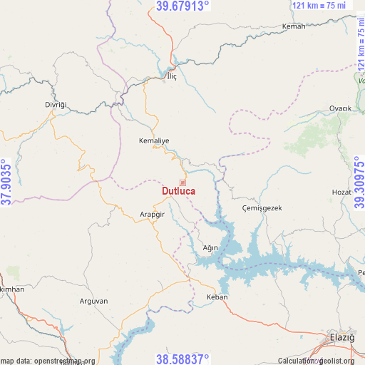
Dutluca GPS coordinates[2]
39° 8' 9.096" North, 38° 36' 23.832" East
| Map corner | latitude | longitude |
|---|---|---|
| Upper-left | 39.67913°, | 37.9035° |
| Center: | 39.13586°, | 38.60662° |
| Lower-right: | 38.58837°, | 39.30975° |
| Map W x H: | 121.3×121.3 km | = 75.4×75.4mi |
| max Lat: | 42.02683° ⇑43.5% North |
| Dutluca: | 39.13586° |
| min Lat: | ⇓56.5% South 35.9025° |
| min Long | Dutluca | max Long |
| 25.90902° | 38.60662° | 44.60099° |
| W 64.6%⇐ | ⇒35.4% E |
Elevation
Elevation of Dutluca is 1171 m = 3842 ft, and this is 453.6 m = 1488 ft above average elevation for this country.
| Max E: |
2682 m = 8799 ft | 21.2% |
| Dutluca | 1171 m 3842 ft | |
| Avg. | 717.4 m = 2354 ft | |
Min E: |
0 m = 0 ft | 78.8% |
See also: Turkey elevation on elevation.city.
Geographical zone
Dutluca is located in North temperate zone (between Tropic of Cancer and the Arctic Circle). Distance of this Northern Tropic circle is 1745.6 km =1084.7 mi to South.| Distance of | km | miles | from Dutluca |
|---|---|---|---|
| North Pole | 5655.6 | 3514.2 | to North |
| Arctic Circle | 3049.7 | 1895 | to North |
| Tropic Cancer | 1745.6 | 1084.7 | to South |
| Equator | 4351.5 | 2703.9 | to South |


Nearby cities:
15 places around Dutluca: (largest is in red/bold)
• Akçapınar
35.8 km =22.2 mi,  125°
125°
• Arapgir
14.3 km =8.9 mi,  222°
222°
• Ağın
23.8 km =14.8 mi,  157°
157°
• Başpınar
9.2 km =5.7 mi,  49°
49°
• Danişment
35.4 km =22 mi,  276°
276°
• Gedikler
18 km =11.2 mi,  109°
109°
• Keban
39.6 km =24.6 mi, 163°
• Kemaliye
17 km =10.6 mi,  326°
326°
• Oğuz
47.5 km =29.5 mi,  30°
30°
• Taşdelen
34.3 km =21.3 mi,  194°
194°
• Yeşilyazı
46.5 km =28.9 mi,  61°
61°
• Yoncalı
33.6 km =20.9 mi,  245°
245°
• Çağlarca
47.2 km =29.3 mi,  103°
103°
• Çemişgezek
27.5 km =17.1 mi, 109°
• İliç
35.3 km =21.9 mi,  353°
353°
Sources, notices
• [Note1] Compared only with cities in Turkey existing in our database
• [Src1] Map data: © OpenStreetMap contributors (CC-BY-SA)
• [Src2] Other city data from geonames.org with taken over terms of usage.
• [Src3] Geographical zone / Annual Mean Temperature by Robert A. Rohde @ Wikipedia
