Başpınar geodata
Başpınar (Erzincan) is a seat of a third-order administrative division; located in Turkey in Europe/Istanbul (GMT+3) time zone. In our database, there are 1323 cities with bigger population. Compared to other cities in Turkey, 57.4% of cities are located further ↓South; 65.1% of cities are located further ←West and 87.2% of cities have lower elevation than Başpınar. Note1


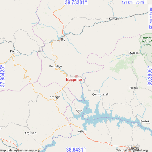
Başpınar GPS coordinates[2]
39° 11' 24.612" North, 38° 41' 14.532" East
| Map corner | latitude | longitude |
|---|---|---|
| Upper-left | 39.73301°, | 37.98425° |
| Center: | 39.19017°, | 38.68737° |
| Lower-right: | 38.6431°, | 39.3905° |
| Map W x H: | 121.2×121.2 km | = 75.3×75.3mi |
| max Lat: | 42.02683° ⇑42.6% North |
| Başpınar: | 39.19017° |
| min Lat: | ⇓57.4% South 35.9025° |
| min Long | Başpınar | max Long |
| 25.90902° | 38.68737° | 44.60099° |
| W 65.1%⇐ | ⇒34.9% E |
Elevation
Elevation of Başpınar is 1374 m = 4508 ft, and this is 656.6 m = 2154 ft above average elevation for this country.
| Max E: |
2682 m = 8799 ft | 12.8% |
| Başpınar | 1374 m 4508 ft | |
| Avg. | 717.4 m = 2354 ft | |
Min E: |
0 m = 0 ft | 87.2% |
See also: Turkey elevation on elevation.city.
Geographical zone
Başpınar is located in North temperate zone (between Tropic of Cancer and the Arctic Circle). Distance of this Northern Tropic circle is 1751.6 km =1088.4 mi to South.| Distance of | km | miles | from Başpınar |
|---|---|---|---|
| North Pole | 5649.5 | 3510.4 | to North |
| Arctic Circle | 3043.6 | 1891.2 | to North |
| Tropic Cancer | 1751.6 | 1088.4 | to South |
| Equator | 4357.5 | 2707.6 | to South |


Nearby cities:
15 places around Başpınar: (largest is in red/bold)
• Akçapınar
34.8 km =21.6 mi,  140°
140°
• Arapgir
23.4 km =14.5 mi,  225°
225°
• Ağın
28.1 km =17.5 mi,  175°
175°
• Danişment
42.2 km =26.2 mi,  267°
267°
• Dutluca
9.2 km =5.7 mi, 229°
• Gedikler
15.6 km =9.7 mi, 140°
• Keban
44.3 km =27.5 mi,  174°
174°
• Kemaliye
18.3 km =11.4 mi,  296°
296°
• Oğuz
39 km =24.2 mi,  25°
25°
• Taşdelen
42.2 km =26.2 mi,  201°
201°
• Yeşilyazı
37.5 km =23.3 mi,  64°
64°
• Yoncalı
42.5 km =26.4 mi,  241°
241°
• Çağlarca
42.5 km =26.4 mi,  113°
113°
• Çemişgezek
24.2 km =15 mi,  128°
128°
• İliç
31.1 km =19.3 mi,  339°
339°
Sources, notices
• [Note1] Compared only with cities in Turkey existing in our database
• [Src1] Map data: © OpenStreetMap contributors (CC-BY-SA)
• [Src2] Other city data from geonames.org with taken over terms of usage.
• [Src3] Geographical zone / Annual Mean Temperature by Robert A. Rohde @ Wikipedia
