Kemaliye geodata
Kemaliye (Erzincan) is a seat of a second-order administrative division; located in Turkey in Europe/Istanbul (GMT+3) time zone. With population of 2,323 people, there are 913 cities with bigger population in this country. Compared to other cities in Turkey, 58.5% of cities are located further ↓South; 64.1% of cities are located further ←West and 64.2% of cities have lower elevation than Kemaliye. Note1


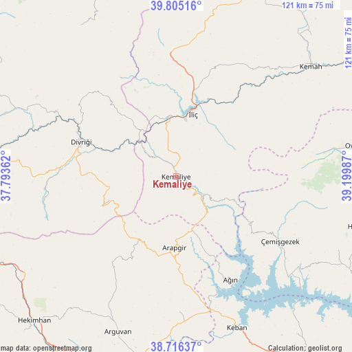
Kemaliye GPS coordinates[2]
39° 15' 46.368" North, 38° 29' 48.264" East
| Map corner | latitude | longitude |
|---|---|---|
| Upper-left | 39.80516°, | 37.79362° |
| Center: | 39.26288°, | 38.49674° |
| Lower-right: | 38.71637°, | 39.19987° |
| Map W x H: | 121.1×121.1 km | = 75.2×75.2mi |
| max Lat: | 42.02683° ⇑41.5% North |
| Kemaliye: | 39.26288° |
| min Lat: | ⇓58.5% South 35.9025° |
| min Long | Kemaliye | max Long |
| 25.90902° | 38.49674° | 44.60099° |
| W 64.1%⇐ | ⇒35.9% E |
Elevation
Elevation of Kemaliye is 948 m = 3110 ft, and this is 230.6 m = 757 ft above average elevation for this country.
| Max E: |
2682 m = 8799 ft | 35.8% |
| Kemaliye | 948 m 3110 ft | |
| Avg. | 717.4 m = 2354 ft | |
Min E: |
0 m = 0 ft | 64.2% |
See also: Turkey elevation on elevation.city.
Geographical zone
Kemaliye is located in North temperate zone (between Tropic of Cancer and the Arctic Circle). Distance of this Northern Tropic circle is 1759.7 km =1093.4 mi to South.| Distance of | km | miles | from Kemaliye |
|---|---|---|---|
| North Pole | 5641.4 | 3505.4 | to North |
| Arctic Circle | 3035.6 | 1886.2 | to North |
| Tropic Cancer | 1759.7 | 1093.4 | to South |
| Equator | 4365.6 | 2712.7 | to South |


Nearby cities:
15 places around Kemaliye: (largest is in red/bold)
• Arapgir
24.7 km =15.3 mi,  180°
180°
• Armutlu
35.3 km =21.9 mi,  350°
350°
• Ağın
40.6 km =25.2 mi,  152°
152°
• Başpınar
18.3 km =11.4 mi,  116°
116°
• Danişment
27.6 km =17.1 mi,  248°
248°
• Divriği
35.1 km =21.8 mi,  290°
290°
• Dutluca
17 km =10.6 mi, 146°
• Gedikbaşı
33.1 km =20.6 mi,  319°
319°
• Gedikler
33.2 km =20.6 mi,  127°
127°
• Kuruçay
42 km =26.1 mi,  357°
357°
• Oğuz
42.8 km =26.6 mi,  50°
50°
• Taşdelen
47.2 km =29.3 mi, 179°
• Yoncalı
35.2 km =21.9 mi,  216°
216°
• Çemişgezek
42.3 km =26.3 mi, 123°
• İliç
21.6 km =13.4 mi,  14°
14°
Sources, notices
• [Note1] Compared only with cities in Turkey existing in our database
• [Src1] Map data: © OpenStreetMap contributors (CC-BY-SA)
• [Src2] Other city data from geonames.org with taken over terms of usage.
• [Src3] Geographical zone / Annual Mean Temperature by Robert A. Rohde @ Wikipedia
