Kemah geodata
Kemah (Erzincan) is a seat of a second-order administrative division; located in Turkey in Europe/Istanbul (GMT+3) time zone. With population of 2,549 people, there are 898 cities with bigger population in this country. Compared to other cities in Turkey, 62.9% of cities are located further ↓South; 67.8% of cities are located further ←West and 74.2% of cities have lower elevation than Kemah. Note1


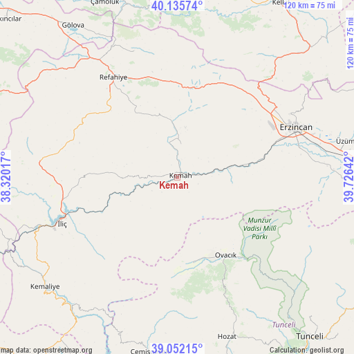
Kemah GPS coordinates[2]
39° 35' 45.816" North, 39° 1' 23.844" East
| Map corner | latitude | longitude |
|---|---|---|
| Upper-left | 40.13574°, | 38.32017° |
| Center: | 39.59606°, | 39.02329° |
| Lower-right: | 39.05215°, | 39.72642° |
| Map W x H: | 120.5×120.5 km | = 74.9×74.9mi |
| max Lat: | 42.02683° ⇑37.1% North |
| Kemah: | 39.59606° |
| min Lat: | ⇓62.9% South 35.9025° |
| min Long | Kemah | max Long |
| 25.90902° | 39.02329° | 44.60099° |
| W 67.8%⇐ | ⇒32.2% E |
Elevation
Elevation of Kemah is 1092 m = 3583 ft, and this is 374.6 m = 1229 ft above average elevation for this country.
| Max E: |
2682 m = 8799 ft | 25.8% |
| Kemah | 1092 m 3583 ft | |
| Avg. | 717.4 m = 2354 ft | |
Min E: |
0 m = 0 ft | 74.2% |
See also: Turkey elevation on elevation.city.
Geographical zone
Kemah is located in North temperate zone (between Tropic of Cancer and the Arctic Circle). Distance of this Northern Tropic circle is 1796.8 km =1116.5 mi to South.| Distance of | km | miles | from Kemah |
|---|---|---|---|
| North Pole | 5604.4 | 3482.4 | to North |
| Arctic Circle | 2998.5 | 1863.2 | to North |
| Tropic Cancer | 1796.8 | 1116.5 | to South |
| Equator | 4402.7 | 2735.7 | to South |


Nearby cities:
15 places around Kemah: (largest is in red/bold)
• Alpköy
14.1 km =8.8 mi,  81°
81°
• Bozoğlak
19.2 km =11.9 mi,  278°
278°
• Cengerli
26.6 km =16.5 mi,  325°
325°
• Doğanbeyli
11.1 km =6.9 mi,  5°
5°
• Erzincan
43 km =26.7 mi,  68°
68°
• Gümüşakar
37.2 km =23.1 mi,  306°
306°
• Karaoğlan
44.1 km =27.4 mi,  158°
158°
• Kuruçay
47.3 km =29.4 mi, 275°
• Ovacık
31.4 km =19.5 mi,  149°
149°
• Oğuz
15.6 km =9.7 mi,  230°
230°
• Refahiye
39.7 km =24.7 mi, 326°
• Yeşilyazı
29.5 km =18.3 mi,  170°
170°
• Çatalarmut
34 km =21.1 mi,  47°
47°
• Çatalçam
44.7 km =27.8 mi,  340°
340°
• İliç
43 km =26.7 mi,  247°
247°
Sources, notices
• [Note1] Compared only with cities in Turkey existing in our database
• [Src1] Map data: © OpenStreetMap contributors (CC-BY-SA)
• [Src2] Other city data from geonames.org with taken over terms of usage.
• [Src3] Geographical zone / Annual Mean Temperature by Robert A. Rohde @ Wikipedia
