Himmetdede geodata
Himmetdede (Kayseri) is a seat of a third-order administrative division; located in Turkey in Europe/Istanbul (GMT+3) time zone. In our database, there are 1323 cities with bigger population. Compared to other cities in Turkey, 53.3% of cities are located further ↓South; 53.8% of cities are located further →East and 81% of cities have lower elevation than Himmetdede. Note1


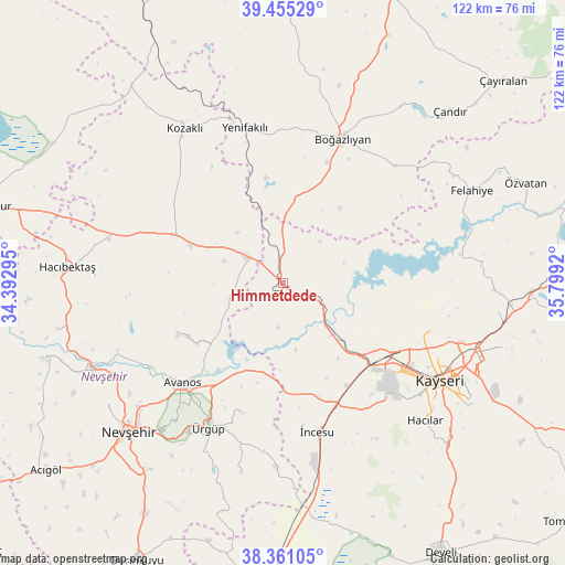
Himmetdede GPS coordinates[2]
38° 54' 37.008" North, 35° 5' 45.852" East
| Map corner | latitude | longitude |
|---|---|---|
| Upper-left | 39.45529°, | 34.39295° |
| Center: | 38.91028°, | 35.09607° |
| Lower-right: | 38.36105°, | 35.7992° |
| Map W x H: | 121.7×121.7 km | = 75.6×75.6mi |
| max Lat: | 42.02683° ⇑46.7% North |
| Himmetdede: | 38.91028° |
| min Lat: | ⇓53.3% South 35.9025° |
| min Long | Himmetdede | max Long |
| 25.90902° | 35.09607° | 44.60099° |
| W 46.2%⇐ | ⇒53.8% E |
Elevation
Elevation of Himmetdede is 1215 m = 3986 ft, and this is 497.6 m = 1633 ft above average elevation for this country.
| Max E: |
2682 m = 8799 ft | 19% |
| Himmetdede | 1215 m 3986 ft | |
| Avg. | 717.4 m = 2354 ft | |
Min E: |
0 m = 0 ft | 81% |
See also: Turkey elevation on elevation.city.
Geographical zone
Himmetdede is located in North temperate zone (between Tropic of Cancer and the Arctic Circle). Distance of this Northern Tropic circle is 1720.5 km =1069.1 mi to South.| Distance of | km | miles | from Himmetdede |
|---|---|---|---|
| North Pole | 5680.6 | 3529.8 | to North |
| Arctic Circle | 3074.8 | 1910.6 | to North |
| Tropic Cancer | 1720.5 | 1069.1 | to South |
| Equator | 4326.4 | 2688.3 | to South |


Nearby cities:
15 places around Himmetdede: (largest is in red/bold)
• Avanos
30.6 km =19 mi,  224°
224°
• Boğazlıyan
33.5 km =20.8 mi,  22°
22°
• Erkilet
31.4 km =19.5 mi,  108°
108°
• Göreme
37.3 km =23.2 mi, 217°
• Gülşehir
44.7 km =27.8 mi,  245°
245°
• Hacılar
42.4 km =26.3 mi,  133°
133°
• Kayseri
39.1 km =24.3 mi,  120°
120°
• Kocasinan
44.1 km =27.4 mi, 110°
• Kozaklı
40.6 km =25.2 mi,  328°
328°
• Melikgazi
35.5 km =22.1 mi, 120°
• Topaklı
25.6 km =15.9 mi,  294°
294°
• Yenifakılı
34.5 km =21.4 mi,  346°
346°
• Özonak
24.6 km =15.3 mi,  243°
243°
• Ürgüp
35.1 km =21.8 mi,  207°
207°
• İncesu
32.9 km =20.4 mi,  166°
166°
Sources, notices
• [Note1] Compared only with cities in Turkey existing in our database
• [Src1] Map data: © OpenStreetMap contributors (CC-BY-SA)
• [Src2] Other city data from geonames.org with taken over terms of usage.
• [Src3] Geographical zone / Annual Mean Temperature by Robert A. Rohde @ Wikipedia
