Avanos geodata
Avanos (Nevşehir) is a seat of a second-order administrative division; located in Turkey in Europe/Istanbul (GMT+3) time zone. With population of 12,833 people, there are 431 cities with bigger population in this country. Compared to other cities in Turkey, 50.3% of cities are located further ↓South; 54.9% of cities are located further →East and 62.8% of cities have lower elevation than Avanos. Note1


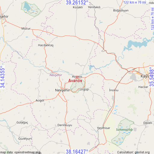
Avanos GPS coordinates[2]
38° 42' 54" North, 34° 50' 48.012" East
| Map corner | latitude | longitude |
|---|---|---|
| Upper-left | 39.26152°, | 34.14355° |
| Center: | 38.715°, | 34.84667° |
| Lower-right: | 38.16427°, | 35.5498° |
| Map W x H: | 122×122 km | = 75.8×75.8mi |
| max Lat: | 42.02683° ⇑49.7% North |
| Avanos: | 38.715° |
| min Lat: | ⇓50.3% South 35.9025° |
| min Long | Avanos | max Long |
| 25.90902° | 34.84667° | 44.60099° |
| W 45.1%⇐ | ⇒54.9% E |
Elevation
Elevation of Avanos is 927 m = 3041 ft, and this is 209.6 m = 688 ft above average elevation for this country.
| Max E: |
2682 m = 8799 ft | 37.2% |
| Avanos | 927 m 3041 ft | |
| Avg. | 717.4 m = 2354 ft | |
Min E: |
0 m = 0 ft | 62.8% |
See also: Turkey elevation on elevation.city.
Geographical zone
Avanos is located in North temperate zone (between Tropic of Cancer and the Arctic Circle). Distance of this Northern Tropic circle is 1698.8 km =1055.6 mi to South.| Distance of | km | miles | from Avanos |
|---|---|---|---|
| North Pole | 5702.4 | 3543.3 | to North |
| Arctic Circle | 3096.5 | 1924.1 | to North |
| Tropic Cancer | 1698.8 | 1055.6 | to South |
| Equator | 4304.7 | 2674.8 | to South |


Nearby cities:
15 places around Avanos: (largest is in red/bold)
• Acıgöl
34.6 km =21.5 mi,  238°
238°
• Derinkuyu
39 km =24.2 mi,  194°
194°
• Erkilet
52.8 km =32.8 mi,  77°
77°
• Göreme
8 km =5 mi, 187°
• Gülşehir
19.5 km =12.1 mi,  280°
280°
• Hacıbektaş
35.5 km =22.1 mi,  315°
315°
• Himmetdede
30.6 km =19 mi,  44°
44°
• Melikgazi
52.5 km =32.6 mi,  85°
85°
• Nevşehir
15.4 km =9.6 mi,  229°
229°
• Salanda
29.9 km =18.6 mi,  294°
294°
• Topaklı
32.4 km =20.1 mi,  356°
356°
• Yeşilhisar
45.5 km =28.3 mi,  152°
152°
• Özonak
10.8 km =6.7 mi, 357°
• Ürgüp
11.1 km =6.9 mi, 149°
• İncesu
30.9 km =19.2 mi,  109°
109°
Sources, notices
• [Note1] Compared only with cities in Turkey existing in our database
• [Src1] Map data: © OpenStreetMap contributors (CC-BY-SA)
• [Src2] Other city data from geonames.org with taken over terms of usage.
• [Src3] Geographical zone / Annual Mean Temperature by Robert A. Rohde @ Wikipedia
