Hacılar geodata
Hacılar (Kayseri) is a seat of a second-order administrative division; located in Turkey in Europe/Istanbul (GMT+3) time zone. With population of 21,167 people, there are 319 cities with bigger population in this country. Compared to other cities in Turkey, 51% of cities are located further ↑North; 52.5% of cities are located further →East and 88.1% of cities have lower elevation than Hacılar. Note1


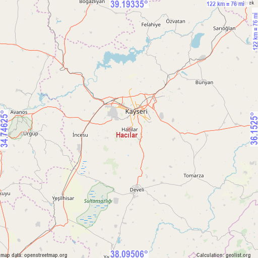
Hacılar GPS coordinates[2]
38° 38' 46.716" North, 35° 26' 57.732" East
| Map corner | latitude | longitude |
|---|---|---|
| Upper-left | 39.19335°, | 34.74625° |
| Center: | 38.64631°, | 35.44937° |
| Lower-right: | 38.09506°, | 36.1525° |
| Map W x H: | 122.1×122.1 km | = 75.9×75.9mi |
| max Lat: | 42.02683° ⇑51% North |
| Hacılar: | 38.64631° |
| min Lat: | ⇓49% South 35.9025° |
| min Long | Hacılar | max Long |
| 25.90902° | 35.44937° | 44.60099° |
| W 47.5%⇐ | ⇒52.5% E |
Elevation
Elevation of Hacılar is 1398 m = 4587 ft, and this is 680.6 m = 2233 ft above average elevation for this country.
| Max E: |
2682 m = 8799 ft | 11.9% |
| Hacılar | 1398 m 4587 ft | |
| Avg. | 717.4 m = 2354 ft | |
Min E: |
0 m = 0 ft | 88.1% |
See also: Turkey elevation on elevation.city.
Geographical zone
Hacılar is located in North temperate zone (between Tropic of Cancer and the Arctic Circle). Distance of this Northern Tropic circle is 1691.1 km =1050.8 mi to South.| Distance of | km | miles | from Hacılar |
|---|---|---|---|
| North Pole | 5710 | 3548 | to North |
| Arctic Circle | 3104.1 | 1928.8 | to North |
| Tropic Cancer | 1691.1 | 1050.8 | to South |
| Equator | 4297.1 | 2670.1 | to South |


Nearby cities:
15 places around Hacılar: (largest is in red/bold)
• Bünyan
42 km =26.1 mi,  58°
58°
• Develi
28.7 km =17.8 mi,  172°
172°
• Elbaşı
45.1 km =28 mi,  86°
86°
• Erkilet
19.4 km =12.1 mi,  357°
357°
• Gesi
24.4 km =15.2 mi,  48°
48°
• Himmetdede
42.4 km =26.3 mi,  313°
313°
• Kayseri
10 km =6.2 mi,  18°
18°
• Kocasinan
17.5 km =10.9 mi,  37°
37°
• Melikgazi
11.5 km =7.1 mi,  0°
0°
• Muncusun
32.4 km =20.1 mi,  28°
28°
• Talas
10.3 km =6.4 mi, 61°
• Tomarza
37.6 km =23.4 mi,  126°
126°
• Yeşilhisar
45.3 km =28.1 mi,  223°
223°
• Ürgüp
46.7 km =29 mi,  267°
267°
• İncesu
23.3 km =14.5 mi,  263°
263°
Sources, notices
• [Note1] Compared only with cities in Turkey existing in our database
• [Src1] Map data: © OpenStreetMap contributors (CC-BY-SA)
• [Src2] Other city data from geonames.org with taken over terms of usage.
• [Src3] Geographical zone / Annual Mean Temperature by Robert A. Rohde @ Wikipedia
