Güzelsu geodata
Güzelsu (Van) is a seat of a third-order administrative division; located in Turkey in Europe/Istanbul (GMT+3) time zone. In our database, there are 1323 cities with bigger population. Compared to other cities in Turkey, 56% of cities are located further ↑North; 99.3% of cities are located further ←West and 99.4% of cities have lower elevation than Güzelsu. Note1


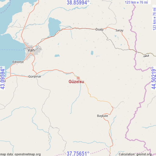
Güzelsu GPS coordinates[2]
38° 18' 37.152" North, 43° 47' 56.616" East
| Map corner | latitude | longitude |
|---|---|---|
| Upper-left | 38.85994°, | 43.09594° |
| Center: | 38.31032°, | 43.79906° |
| Lower-right: | 37.75651°, | 44.50219° |
| Map W x H: | 122.7×122.7 km | = 76.2×76.2mi |
| max Lat: | 42.02683° ⇑56% North |
| Güzelsu: | 38.31032° |
| min Lat: | ⇓44% South 35.9025° |
| min Long | Güzelsu | max Long |
| 25.90902° | 43.79906° | 44.60099° |
| W 99.3%⇐ | ⇒0.7% E |
Elevation
Elevation of Güzelsu is 2070 m = 6791 ft, and this is 1352.6 m = 4438 ft above average elevation for this country.
| Max E: |
2682 m = 8799 ft | 0.59999999999999% |
| Güzelsu | 2070 m 6791 ft | |
| Avg. | 717.4 m = 2354 ft | |
Min E: |
0 m = 0 ft | 99.4% |
See also: Turkey elevation on elevation.city.
Geographical zone
Güzelsu is located in North temperate zone (between Tropic of Cancer and the Arctic Circle). Distance of this Northern Tropic circle is 1653.8 km =1027.6 mi to South.| Distance of | km | miles | from Güzelsu |
|---|---|---|---|
| North Pole | 5747.4 | 3571.3 | to North |
| Arctic Circle | 3141.5 | 1952 | to North |
| Tropic Cancer | 1653.8 | 1027.6 | to South |
| Equator | 4259.7 | 2646.9 | to South |


Nearby cities:
15 places around Güzelsu: (largest is in red/bold)
• Albayrak
39.8 km =24.7 mi,  117°
117°
• Başkale
35.1 km =21.8 mi,  147°
147°
• Dorutay
59.2 km =36.8 mi,  23°
23°
• Edremit
48.7 km =30.3 mi,  284°
284°
• Erçek
40.2 km =25 mi,  340°
340°
• Gevaş
60.9 km =37.8 mi,  268°
268°
• Gürpınar
34 km =21.1 mi, 272°
• Hazekyan
69.1 km =42.9 mi,  162°
162°
• Kırkgeçit
33 km =20.5 mi,  233°
233°
• Saray
48.9 km =30.4 mi,  40°
40°
• Sözveren
72.3 km =44.9 mi,  240°
240°
• Timar
65.8 km =40.9 mi,  331°
331°
• Van
41.6 km =25.8 mi,  299°
299°
• Yalınca
56 km =34.8 mi,  205°
205°
• Özalp
41.7 km =25.9 mi, 23°
Sources, notices
• [Note1] Compared only with cities in Turkey existing in our database
• [Src1] Map data: © OpenStreetMap contributors (CC-BY-SA)
• [Src2] Other city data from geonames.org with taken over terms of usage.
• [Src3] Geographical zone / Annual Mean Temperature by Robert A. Rohde @ Wikipedia
