Gevaş geodata
Gevaş (Van) is a seat of a second-order administrative division; located in Turkey in Europe/Istanbul (GMT+3) time zone. With population of 11,879 people, there are 453 cities with bigger population in this country. Compared to other cities in Turkey, 56.4% of cities are located further ↑North; 97.2% of cities are located further ←West and 95.8% of cities have lower elevation than Gevaş. Note1


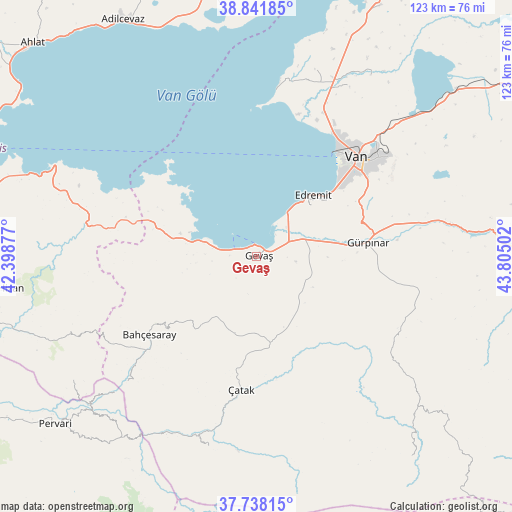
Gevaş GPS coordinates[2]
38° 17' 31.56" North, 43° 6' 6.804" East
| Map corner | latitude | longitude |
|---|---|---|
| Upper-left | 38.84185°, | 42.39877° |
| Center: | 38.2921°, | 43.10189° |
| Lower-right: | 37.73815°, | 43.80502° |
| Map W x H: | 122.7×122.7 km | = 76.2×76.2mi |
| max Lat: | 42.02683° ⇑56.4% North |
| Gevaş: | 38.2921° |
| min Lat: | ⇓43.6% South 35.9025° |
| min Long | Gevaş | max Long |
| 25.90902° | 43.10189° | 44.60099° |
| W 97.2%⇐ | ⇒2.8% E |
Elevation
Elevation of Gevaş is 1722 m = 5650 ft, and this is 1004.6 m = 3296 ft above average elevation for this country.
| Max E: |
2682 m = 8799 ft | 4.2% |
| Gevaş | 1722 m 5650 ft | |
| Avg. | 717.4 m = 2354 ft | |
Min E: |
0 m = 0 ft | 95.8% |
See also: Turkey elevation on elevation.city.
Geographical zone
Gevaş is located in North temperate zone (between Tropic of Cancer and the Arctic Circle). Distance of this Northern Tropic circle is 1651.8 km =1026.4 mi to South.| Distance of | km | miles | from Gevaş |
|---|---|---|---|
| North Pole | 5749.4 | 3572.5 | to North |
| Arctic Circle | 3143.5 | 1953.3 | to North |
| Tropic Cancer | 1651.8 | 1026.4 | to South |
| Equator | 4257.7 | 2645.6 | to South |


Nearby cities:
15 places around Gevaş: (largest is in red/bold)
• Atlıhan
48.2 km =30 mi,  210°
210°
• Bahçesaray
32.4 km =20.1 mi,  234°
234°
• Belenoluk
50.6 km =31.4 mi, 214°
• Edremit
19.8 km =12.3 mi,  43°
43°
• Gürpınar
27.1 km =16.8 mi,  82°
82°
• Kaçıt
41.4 km =25.7 mi,  193°
193°
• Konalga
48 km =29.8 mi,  180°
180°
• Kırkgeçit
38.4 km =23.9 mi,  116°
116°
• Narlı
46.6 km =29 mi, 193°
• Simos
52.3 km =32.5 mi,  240°
240°
• Sözveren
33.6 km =20.9 mi, 183°
• Uzyum
47.3 km =29.4 mi, 226°
• Van
33.3 km =20.7 mi,  47°
47°
• Çatak
32.4 km =20.1 mi, 187°
• Övecek
47.2 km =29.3 mi,  203°
203°
Sources, notices
• [Note1] Compared only with cities in Turkey existing in our database
• [Src1] Map data: © OpenStreetMap contributors (CC-BY-SA)
• [Src2] Other city data from geonames.org with taken over terms of usage.
• [Src3] Geographical zone / Annual Mean Temperature by Robert A. Rohde @ Wikipedia
