Kırkgeçit geodata
Kırkgeçit (Van) is a seat of a third-order administrative division; located in Turkey in Europe/Istanbul (GMT+3) time zone. In our database, there are 1323 cities with bigger population. Compared to other cities in Turkey, 59.2% of cities are located further ↑North; 98.7% of cities are located further ←West and 99.5% of cities have lower elevation than Kırkgeçit. Note1


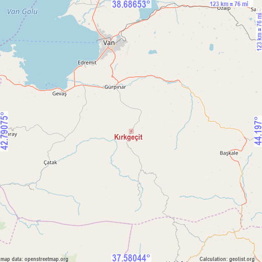
Kırkgeçit GPS coordinates[2]
38° 8' 8.088" North, 43° 29' 37.932" East
| Map corner | latitude | longitude |
|---|---|---|
| Upper-left | 38.68653°, | 42.79075° |
| Center: | 38.13558°, | 43.49387° |
| Lower-right: | 37.58044°, | 44.197° |
| Map W x H: | 123×123 km | = 76.4×76.4mi |
| max Lat: | 42.02683° ⇑59.2% North |
| Kırkgeçit: | 38.13558° |
| min Lat: | ⇓40.8% South 35.9025° |
| min Long | Kırkgeçit | max Long |
| 25.90902° | 43.49387° | 44.60099° |
| W 98.7%⇐ | ⇒1.3% E |
Elevation
Elevation of Kırkgeçit is 2087 m = 6847 ft, and this is 1369.6 m = 4493 ft above average elevation for this country.
| Max E: |
2682 m = 8799 ft | 0.5% |
| Kırkgeçit | 2087 m 6847 ft | |
| Avg. | 717.4 m = 2354 ft | |
Min E: |
0 m = 0 ft | 99.5% |
See also: Turkey elevation on elevation.city.
Geographical zone
Kırkgeçit is located in North temperate zone (between Tropic of Cancer and the Arctic Circle). Distance of this Northern Tropic circle is 1634.4 km =1015.6 mi to South.| Distance of | km | miles | from Kırkgeçit |
|---|---|---|---|
| North Pole | 5766.8 | 3583.3 | to North |
| Arctic Circle | 3160.9 | 1964.1 | to North |
| Tropic Cancer | 1634.4 | 1015.6 | to South |
| Equator | 4240.3 | 2634.8 | to South |


Nearby cities:
15 places around Kırkgeçit: (largest is in red/bold)
• Başkale
46.9 km =29.1 mi,  102°
102°
• Buğdaylı
55.1 km =34.2 mi,  204°
204°
• Edremit
37.8 km =23.5 mi,  327°
327°
• Erçek
58.8 km =36.5 mi,  12°
12°
• Gevaş
38.4 km =23.9 mi,  296°
296°
• Gürpınar
22.2 km =13.8 mi,  340°
340°
• Güzelsu
33 km =20.5 mi,  53°
53°
• Kaçıt
49.8 km =30.9 mi,  242°
242°
• Konalga
46.3 km =28.8 mi,  228°
228°
• Mezraa
59 km =36.7 mi,  206°
206°
• Narlı
53.3 km =33.1 mi, 238°
• Sözveren
39.7 km =24.7 mi,  246°
246°
• Van
41.1 km =25.5 mi,  346°
346°
• Yalınca
31.1 km =19.3 mi,  175°
175°
• Çatak
41.4 km =25.7 mi, 249°
Sources, notices
• [Note1] Compared only with cities in Turkey existing in our database
• [Src1] Map data: © OpenStreetMap contributors (CC-BY-SA)
• [Src2] Other city data from geonames.org with taken over terms of usage.
• [Src3] Geographical zone / Annual Mean Temperature by Robert A. Rohde @ Wikipedia
