Dorutay geodata
Dorutay (Van) is a seat of a third-order administrative division; located in Turkey in Europe/Istanbul (GMT+3) time zone. In our database, there are 1323 cities with bigger population. Compared to other cities in Turkey, 51.8% of cities are located further ↓South; 99.6% of cities are located further ←West and 99.1% of cities have lower elevation than Dorutay. Note1


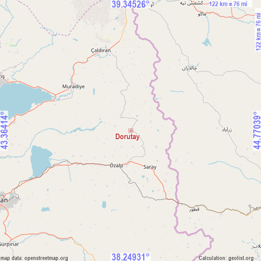
Dorutay GPS coordinates[2]
38° 47' 57.804" North, 44° 4' 2.136" East
| Map corner | latitude | longitude |
|---|---|---|
| Upper-left | 39.34526°, | 43.36414° |
| Center: | 38.79939°, | 44.06726° |
| Lower-right: | 38.24931°, | 44.77039° |
| Map W x H: | 121.9×121.9 km | = 75.7×75.7mi |
| max Lat: | 42.02683° ⇑48.2% North |
| Dorutay: | 38.79939° |
| min Lat: | ⇓51.8% South 35.9025° |
| min Long | Dorutay | max Long |
| 25.90902° | 44.06726° | 44.60099° |
| W 99.6%⇐ | ⇒0.40000000000001% E |
Elevation
Elevation of Dorutay is 2034 m = 6673 ft, and this is 1316.6 m = 4320 ft above average elevation for this country.
| Max E: |
2682 m = 8799 ft | 0.90000000000001% |
| Dorutay | 2034 m 6673 ft | |
| Avg. | 717.4 m = 2354 ft | |
Min E: |
0 m = 0 ft | 99.1% |
See also: Turkey elevation on elevation.city.
Geographical zone
Dorutay is located in North temperate zone (between Tropic of Cancer and the Arctic Circle). Distance of this Northern Tropic circle is 1708.2 km =1061.4 mi to South.| Distance of | km | miles | from Dorutay |
|---|---|---|---|
| North Pole | 5693 | 3537.5 | to North |
| Arctic Circle | 3087.1 | 1918.2 | to North |
| Tropic Cancer | 1708.2 | 1061.4 | to South |
| Equator | 4314.1 | 2680.7 | to South |


Nearby cities:
15 places around Dorutay: (largest is in red/bold)
• Albayrak
74 km =46 mi,  170°
170°
• Deliçay
59.3 km =36.8 mi,  301°
301°
• Doğubayazıt
83.1 km =51.6 mi,  1°
1°
• Edremit
81.9 km =50.9 mi,  239°
239°
• Erciş
66.2 km =41.1 mi,  292°
292°
• Erçek
40.2 km =25 mi,  245°
245°
• Gürpınar
77.9 km =48.4 mi,  227°
227°
• Güzelsu
59.2 km =36.8 mi,  203°
203°
• Kocapınar
82.2 km =51.1 mi, 293°
• Muradiye
34.2 km =21.3 mi,  307°
307°
• Saray
18.8 km =11.7 mi,  154°
154°
• Timar
55 km =34.2 mi,  273°
273°
• Van
68.4 km =42.5 mi, 240°
• Çaldıran
40.6 km =25.2 mi,  340°
340°
• Özalp
17.5 km =10.9 mi, 202°
Sources, notices
• [Note1] Compared only with cities in Turkey existing in our database
• [Src1] Map data: © OpenStreetMap contributors (CC-BY-SA)
• [Src2] Other city data from geonames.org with taken over terms of usage.
• [Src3] Geographical zone / Annual Mean Temperature by Robert A. Rohde @ Wikipedia
