Başkale geodata
Başkale (Van) is a seat of a second-order administrative division; located in Turkey in Europe/Istanbul (GMT+3) time zone. With population of 14,516 people, there are 400 cities with bigger population in this country. Compared to other cities in Turkey, 60.6% of cities are located further ↑North; 99.4% of cities are located further ←West and 99.9% of cities have lower elevation than Başkale. Note1


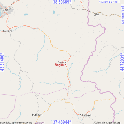
Başkale GPS coordinates[2]
38° 2' 42.936" North, 44° 1' 1.848" East
| Map corner | latitude | longitude |
|---|---|---|
| Upper-left | 38.59689°, | 43.31406° |
| Center: | 38.04526°, | 44.01718° |
| Lower-right: | 37.48944°, | 44.72031° |
| Map W x H: | 123.1×123.1 km | = 76.5×76.5mi |
| max Lat: | 42.02683° ⇑60.6% North |
| Başkale: | 38.04526° |
| min Lat: | ⇓39.4% South 35.9025° |
| min Long | Başkale | max Long |
| 25.90902° | 44.01718° | 44.60099° |
| W 99.4%⇐ | ⇒0.59999999999999% E |
Elevation
Elevation of Başkale is 2297 m = 7536 ft, and this is 1579.6 m = 5182 ft above average elevation for this country.
| Max E: |
2682 m = 8799 ft | 0.099999999999994% |
| Başkale | 2297 m 7536 ft | |
| Avg. | 717.4 m = 2354 ft | |
Min E: |
0 m = 0 ft | 99.9% |
See also: Turkey elevation on elevation.city.
Geographical zone
Başkale is located in North temperate zone (between Tropic of Cancer and the Arctic Circle). Distance of this Northern Tropic circle is 1624.3 km =1009.3 mi to South.| Distance of | km | miles | from Başkale |
|---|---|---|---|
| North Pole | 5776.8 | 3589.5 | to North |
| Arctic Circle | 3170.9 | 1970.3 | to North |
| Tropic Cancer | 1624.3 | 1009.3 | to South |
| Equator | 4230.2 | 2628.5 | to South |


Nearby cities:
15 places around Başkale: (largest is in red/bold)
• Albayrak
19.4 km =12.1 mi,  56°
56°
• Dağlıca
75.7 km =47 mi,  175°
175°
• Erçek
74.8 km =46.5 mi,  334°
334°
• Esendere
63.3 km =39.3 mi,  125°
125°
• Geçitli
64.8 km =40.3 mi,  218°
218°
• Gürpınar
61.4 km =38.2 mi,  300°
300°
• Güzelsu
35.1 km =21.8 mi, 327°
• Hakkâri
57.7 km =35.9 mi,  204°
204°
• Hazekyan
36.5 km =22.7 mi, 177°
• Kırkgeçit
46.9 km =29.1 mi,  282°
282°
• Saray
68.1 km =42.3 mi,  10°
10°
• Van
74.6 km =46.4 mi,  312°
312°
• Yalınca
48.2 km =30 mi,  244°
244°
• Yüksekova
57.6 km =35.8 mi,  155°
155°
• Özalp
67.8 km =42.1 mi,  357°
357°
Sources, notices
• [Note1] Compared only with cities in Turkey existing in our database
• [Src1] Map data: © OpenStreetMap contributors (CC-BY-SA)
• [Src2] Other city data from geonames.org with taken over terms of usage.
• [Src3] Geographical zone / Annual Mean Temperature by Robert A. Rohde @ Wikipedia
