Karaköprü geodata
Karaköprü (Şanlıurfa) is a seat of a second-order administrative division; located in Turkey in Europe/Istanbul (GMT+3) time zone. In our database, there are 1323 cities with bigger population. Compared to other cities in Turkey, 83.2% of cities are located further ↑North; 66% of cities are located further ←West and 55.1% of cities have higher elevation than Karaköprü. Note1


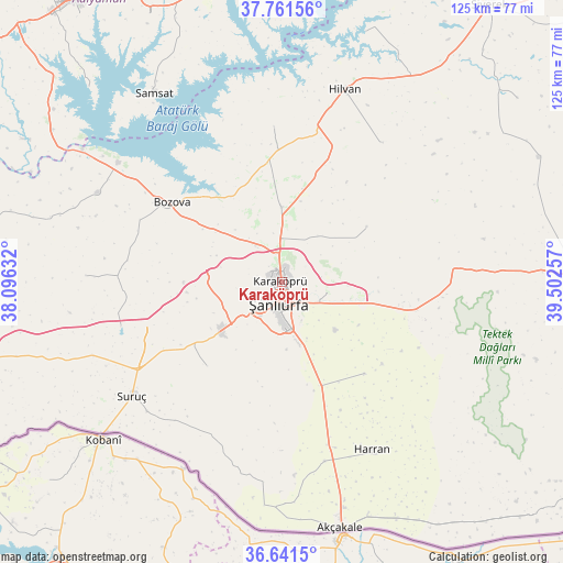
Karaköprü GPS coordinates[2]
37° 12' 12.996" North, 38° 47' 57.984" East
| Map corner | latitude | longitude |
|---|---|---|
| Upper-left | 37.76156°, | 38.09632° |
| Center: | 37.20361°, | 38.79944° |
| Lower-right: | 36.6415°, | 39.50257° |
| Map W x H: | 124.5×124.5 km | = 77.4×77.4mi |
| max Lat: | 42.02683° ⇑83.2% North |
| Karaköprü: | 37.20361° |
| min Lat: | ⇓16.8% South 35.9025° |
| min Long | Karaköprü | max Long |
| 25.90902° | 38.79944° | 44.60099° |
| W 66%⇐ | ⇒34% E |
Elevation
Elevation of Karaköprü is 586 m = 1923 ft, and this is 131.4 m = 431 ft below average elevation for this country.
| Max E: |
2682 m = 8799 ft | 55.1% |
| Avg. | 717.4 m = 2354 ft | |
| Karaköprü | 586 m = 1923 ft | |
Min E: |
0 m = 0 ft | 44.9% |
See also: Turkey elevation on elevation.city.
Geographical zone
Karaköprü is located in North temperate zone (between Tropic of Cancer and the Arctic Circle). Distance of this Northern Tropic circle is 1530.7 km =951.1 mi to South.| Distance of | km | miles | from Karaköprü |
|---|---|---|---|
| North Pole | 5870.4 | 3647.7 | to North |
| Arctic Circle | 3264.5 | 2028.5 | to North |
| Tropic Cancer | 1530.7 | 951.1 | to South |
| Equator | 4136.7 | 2570.4 | to South |


Nearby cities:
15 places around Karaköprü: (largest is in red/bold)
• Akziyaret
16.6 km =10.3 mi,  358°
358°
• Bozova
29.9 km =18.6 mi,  306°
306°
• Kabahaydar
22.3 km =13.9 mi,  56°
56°
• Kabahaydar
33.3 km =20.7 mi,  48°
48°
• Karatepe
34.7 km =21.6 mi,  168°
168°
• Keçikıran
31.1 km =19.3 mi,  148°
148°
• Ovacık
34.5 km =21.4 mi, 357°
• Ozanlar
30.1 km =18.7 mi,  162°
162°
• Parapara
31.3 km =19.4 mi, 155°
• Payamlı
24.8 km =15.4 mi,  221°
221°
• Yardımcı
27.3 km =17 mi,  138°
138°
• Yediyol
26.4 km =16.4 mi, 153°
• Yukarı Çaykuyu
23.6 km =14.7 mi,  190°
190°
• Çamlıdere
24.3 km =15.1 mi,  102°
102°
• Şanlıurfa
4.1 km =2.5 mi, 186°
Sources, notices
• [Note1] Compared only with cities in Turkey existing in our database
• [Src1] Map data: © OpenStreetMap contributors (CC-BY-SA)
• [Src2] Other city data from geonames.org with taken over terms of usage.
• [Src3] Geographical zone / Annual Mean Temperature by Robert A. Rohde @ Wikipedia
