Şanlıurfa geodata
Şanlıurfa is a seat of a first-order administrative division; located in Turkey in Europe/Istanbul (GMT+3) time zone. With population of 449,549 people, there are 20 cities with bigger population in this country. Compared to other cities in Turkey, 84.4% of cities are located further ↑North; 65.8% of cities are located further ←West and 58.4% of cities have higher elevation than Şanlıurfa. Note1


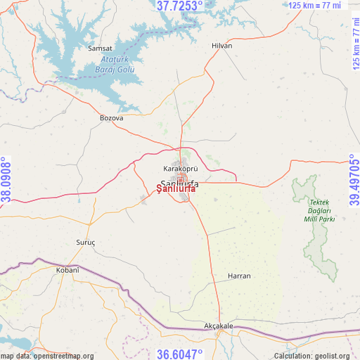
Şanlıurfa GPS coordinates[2]
37° 10' 1.488" North, 38° 47' 38.112" East
| Map corner | latitude | longitude |
|---|---|---|
| Upper-left | 37.7253°, | 38.0908° |
| Center: | 37.16708°, | 38.79392° |
| Lower-right: | 36.6047°, | 39.49705° |
| Map W x H: | 124.6×124.6 km | = 77.4×77.4mi |
| max Lat: | 42.02683° ⇑84.4% North |
| Şanlıurfa: | 37.16708° |
| min Lat: | ⇓15.6% South 35.9025° |
| min Long | Şanlıurfa | max Long |
| 25.90902° | 38.79392° | 44.60099° |
| W 65.8%⇐ | ⇒34.2% E |
Elevation
Elevation of Şanlıurfa is 528 m = 1732 ft, and this is 189.4 m = 621 ft below average elevation for this country.
| Max E: |
2682 m = 8799 ft | 58.4% |
| Avg. | 717.4 m = 2354 ft | |
| Şanlıurfa | 528 m = 1732 ft | |
Min E: |
0 m = 0 ft | 41.6% |
See also: Şanlıurfa elevation on elevation.city.
Geographical zone
Şanlıurfa is located in North temperate zone (between Tropic of Cancer and the Arctic Circle). Distance of this Northern Tropic circle is 1526.7 km =948.6 mi to South.| Distance of | km | miles | from Şanlıurfa |
|---|---|---|---|
| North Pole | 5874.5 | 3650.2 | to North |
| Arctic Circle | 3268.6 | 2031 | to North |
| Tropic Cancer | 1526.7 | 948.6 | to South |
| Equator | 4132.6 | 2567.9 | to South |


Nearby cities:
15 places around Şanlıurfa: (largest is in red/bold)
• Akziyaret
20.7 km =12.9 mi,  0°
0°
• Boybeyi
30.9 km =19.2 mi,  193°
193°
• Bozova
32.1 km =19.9 mi,  312°
312°
• Kabahaydar
25.1 km =15.6 mi,  49°
49°
• Karaköprü
4.1 km =2.5 mi,  6°
6°
• Karatepe
30.8 km =19.1 mi,  165°
165°
• Keçikıran
28 km =17.4 mi,  142°
142°
• Minare
32.2 km =20 mi, 144°
• Ozanlar
26.4 km =16.4 mi,  159°
159°
• Parapara
27.9 km =17.3 mi,  151°
151°
• Payamlı
21.6 km =13.4 mi,  227°
227°
• Yardımcı
24.8 km =15.4 mi,  130°
130°
• Yediyol
23.1 km =14.4 mi, 148°
• Yukarı Çaykuyu
19.5 km =12.1 mi, 191°
• Çamlıdere
24.2 km =15 mi,  93°
93°
Sources, notices
• [Note1] Compared only with cities in Turkey existing in our database
• [Src1] Map data: © OpenStreetMap contributors (CC-BY-SA)
• [Src2] Other city data from geonames.org with taken over terms of usage.
• [Src3] Geographical zone / Annual Mean Temperature by Robert A. Rohde @ Wikipedia
