Gölova geodata
Gölova (Antalya) is a seat of a third-order administrative division; located in Turkey in Europe/Istanbul (GMT+3) time zone. In our database, there are 1323 cities with bigger population. Compared to other cities in Turkey, 93.3% of cities are located further ↑North; 75.4% of cities are located further →East and 75.4% of cities have lower elevation than Gölova. Note1


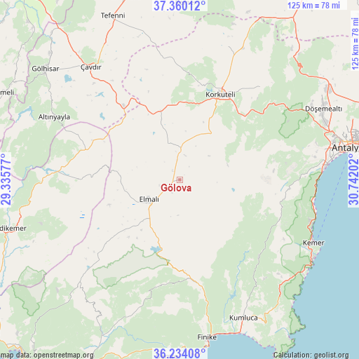
Gölova GPS coordinates[2]
36° 47' 57.012" North, 30° 2' 20.004" East
| Map corner | latitude | longitude |
|---|---|---|
| Upper-left | 37.36012°, | 29.33577° |
| Center: | 36.79917°, | 30.03889° |
| Lower-right: | 36.23408°, | 30.74202° |
| Map W x H: | 125.2×125.2 km | = 77.8×77.8mi |
| max Lat: | 42.02683° ⇑93.3% North |
| Gölova: | 36.79917° |
| min Lat: | ⇓6.7% South 35.9025° |
| min Long | Gölova | max Long |
| 25.90902° | 30.03889° | 44.60099° |
| W 24.6%⇐ | ⇒75.4% E |
Elevation
Elevation of Gölova is 1114 m = 3655 ft, and this is 396.6 m = 1301 ft above average elevation for this country.
| Max E: |
2682 m = 8799 ft | 24.6% |
| Gölova | 1114 m 3655 ft | |
| Avg. | 717.4 m = 2354 ft | |
Min E: |
0 m = 0 ft | 75.4% |
See also: Turkey elevation on elevation.city.
Geographical zone
Gölova is located in North temperate zone (between Tropic of Cancer and the Arctic Circle). Distance of this Northern Tropic circle is 1485.8 km =923.2 mi to South.| Distance of | km | miles | from Gölova |
|---|---|---|---|
| North Pole | 5915.4 | 3675.7 | to North |
| Arctic Circle | 3309.5 | 2056.4 | to North |
| Tropic Cancer | 1485.8 | 923.2 | to South |
| Equator | 4091.7 | 2542.5 | to South |


Nearby cities:
15 places around Gölova: (largest is in red/bold)
• Akçay
34.1 km =21.2 mi,  229°
229°
• Altınyaka
38.4 km =23.9 mi,  134°
134°
• Altınyayla
49.1 km =30.5 mi,  296°
296°
• Bozova
51.3 km =31.9 mi,  25°
25°
• Elmalı
12.9 km =8 mi,  236°
236°
• Geyikbayırı
38.3 km =23.8 mi,  77°
77°
• Göynük
48.1 km =29.9 mi,  108°
108°
• Kemer
51.6 km =32.1 mi,  115°
115°
• Korkuteli
32.7 km =20.3 mi, 25°
• Kızılcadağ
25.2 km =15.7 mi,  344°
344°
• Kızılyaka
49.8 km =30.9 mi,  294°
294°
• Seki
34.5 km =21.4 mi,  270°
270°
• Turunçova
48.6 km =30.2 mi,  169°
169°
• Çakırlar
47.2 km =29.3 mi, 80°
• Çavdır
50 km =31.1 mi,  322°
322°
Sources, notices
• [Note1] Compared only with cities in Turkey existing in our database
• [Src1] Map data: © OpenStreetMap contributors (CC-BY-SA)
• [Src2] Other city data from geonames.org with taken over terms of usage.
• [Src3] Geographical zone / Annual Mean Temperature by Robert A. Rohde @ Wikipedia
