Turunçova geodata
Turunçova (Antalya) is a populated place; located in Turkey in Europe/Istanbul (GMT+3) time zone. With population of 8,356 people, there are 563 cities with bigger population in this country. Compared to other cities in Turkey, 97.4% of cities are located further ↑North; 75.2% of cities are located further →East and 88.4% of cities have higher elevation than Turunçova. Note1


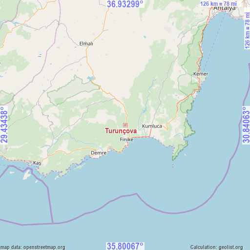
Turunçova GPS coordinates[2]
36° 22' 8.004" North, 30° 8' 15" East
| Map corner | latitude | longitude |
|---|---|---|
| Upper-left | 36.93299°, | 29.43438° |
| Center: | 36.36889°, | 30.1375° |
| Lower-right: | 35.80067°, | 30.84063° |
| Map W x H: | 125.9×125.9 km | = 78.2×78.2mi |
| max Lat: | 42.02683° ⇑97.4% North |
| Turunçova: | 36.36889° |
| min Lat: | ⇓2.6% South 35.9025° |
| min Long | Turunçova | max Long |
| 25.90902° | 30.1375° | 44.60099° |
| W 24.8%⇐ | ⇒75.2% E |
Elevation
Elevation of Turunçova is 48 m = 157 ft, and this is 669.4 m = 2196 ft below average elevation for this country.
| Max E: |
2682 m = 8799 ft | 88.4% |
| Avg. | 717.4 m = 2354 ft | |
| Turunçova | 48 m = 157 ft | |
Min E: |
0 m = 0 ft | 11.6% |
See also: Turkey elevation on elevation.city.
Geographical zone
Turunçova is located in North temperate zone (between Tropic of Cancer and the Arctic Circle). Distance of this Northern Tropic circle is 1437.9 km =893.5 mi to South.| Distance of | km | miles | from Turunçova |
|---|---|---|---|
| North Pole | 5963.2 | 3705.4 | to North |
| Arctic Circle | 3357.3 | 2086.1 | to North |
| Tropic Cancer | 1437.9 | 893.5 | to South |
| Equator | 4043.8 | 2512.7 | to South |


Nearby cities:
15 places around Turunçova: (largest is in red/bold)
• Akçay
43.5 km =27 mi,  306°
306°
• Altınyaka
28.3 km =17.6 mi,  41°
41°
• Beykonak
15.6 km =9.7 mi,  107°
107°
• Demre
19.4 km =12.1 mi,  224°
224°
• Elmalı
45.3 km =28.1 mi,  334°
334°
• Finike
8.2 km =5.1 mi,  178°
178°
• Geyikbayırı
63.2 km =39.3 mi,  26°
26°
• Gölova
48.6 km =30.2 mi,  349°
349°
• Göynük
49.1 km =30.5 mi,  48°
48°
• Kalkan
65.9 km =40.9 mi,  259°
259°
• Kaş
48.5 km =30.1 mi,  247°
247°
• Kemer
45.6 km =28.3 mi,  56°
56°
• Kumluca
13.4 km =8.3 mi,  89°
89°
• Seki
65 km =40.4 mi,  318°
318°
• Tekirova
37.9 km =23.5 mi,  67°
67°
Sources, notices
• [Note1] Compared only with cities in Turkey existing in our database
• [Src1] Map data: © OpenStreetMap contributors (CC-BY-SA)
• [Src2] Other city data from geonames.org with taken over terms of usage.
• [Src3] Geographical zone / Annual Mean Temperature by Robert A. Rohde @ Wikipedia
