Altınyaka geodata
Altınyaka (Antalya) is a seat of a third-order administrative division; located in Turkey in Europe/Istanbul (GMT+3) time zone. In our database, there are 1323 cities with bigger population. Compared to other cities in Turkey, 96.7% of cities are located further ↑North; 73.9% of cities are located further →East and 66.5% of cities have lower elevation than Altınyaka. Note1


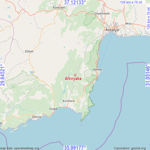
Altınyaka GPS coordinates[2]
36° 33' 30.996" North, 30° 20' 53.988" East
| Map corner | latitude | longitude |
|---|---|---|
| Upper-left | 37.12133°, | 29.64521° |
| Center: | 36.55861°, | 30.34833° |
| Lower-right: | 35.99177°, | 31.05146° |
| Map W x H: | 125.6×125.6 km | = 78×78mi |
| max Lat: | 42.02683° ⇑96.7% North |
| Altınyaka: | 36.55861° |
| min Lat: | ⇓3.3% South 35.9025° |
| min Long | Altınyaka | max Long |
| 25.90902° | 30.34833° | 44.60099° |
| W 26.1%⇐ | ⇒73.9% E |
Elevation
Elevation of Altınyaka is 980 m = 3215 ft, and this is 262.6 m = 862 ft above average elevation for this country.
| Max E: |
2682 m = 8799 ft | 33.5% |
| Altınyaka | 980 m 3215 ft | |
| Avg. | 717.4 m = 2354 ft | |
Min E: |
0 m = 0 ft | 66.5% |
See also: Turkey elevation on elevation.city.
Geographical zone
Altınyaka is located in North temperate zone (between Tropic of Cancer and the Arctic Circle). Distance of this Northern Tropic circle is 1459 km =906.6 mi to South.| Distance of | km | miles | from Altınyaka |
|---|---|---|---|
| North Pole | 5942.1 | 3692.2 | to North |
| Arctic Circle | 3336.2 | 2073 | to North |
| Tropic Cancer | 1459 | 906.6 | to South |
| Equator | 4064.9 | 2525.8 | to South |


Nearby cities:
15 places around Altınyaka: (largest is in red/bold)
• Antalya
49.7 km =30.9 mi,  38°
38°
• Beykonak
26.2 km =16.3 mi,  188°
188°
• Demre
47.7 km =29.6 mi,  222°
222°
• Elmalı
43.2 km =26.8 mi,  297°
297°
• Finike
34.7 km =21.6 mi,  212°
212°
• Geyikbayırı
36.6 km =22.7 mi,  15°
15°
• Gölova
38.4 km =23.9 mi,  314°
314°
• Göynük
21.2 km =13.2 mi,  57°
57°
• Kemer
19.4 km =12.1 mi,  77°
77°
• Kepez
51 km =31.7 mi, 38°
• Konyaaltı
42.5 km =26.4 mi, 36°
• Kumluca
21.6 km =13.4 mi, 194°
• Tekirova
17.2 km =10.7 mi,  111°
111°
• Turunçova
28.3 km =17.6 mi, 221°
• Çakırlar
39.7 km =24.7 mi,  28°
28°
Sources, notices
• [Note1] Compared only with cities in Turkey existing in our database
• [Src1] Map data: © OpenStreetMap contributors (CC-BY-SA)
• [Src2] Other city data from geonames.org with taken over terms of usage.
• [Src3] Geographical zone / Annual Mean Temperature by Robert A. Rohde @ Wikipedia
