Kemer geodata
Kemer (Antalya) is a populated place; located in Turkey in Europe/Istanbul (GMT+3) time zone. With population of 17,300 people, there are 358 cities with bigger population in this country. Compared to other cities in Turkey, 96.4% of cities are located further ↑North; 72.5% of cities are located further →East and 93.2% of cities have higher elevation than Kemer. Note1


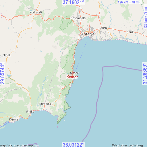
Kemer GPS coordinates[2]
36° 35' 52.008" North, 30° 33' 38.016" East
| Map corner | latitude | longitude |
|---|---|---|
| Upper-left | 37.16021°, | 29.85744° |
| Center: | 36.59778°, | 30.56056° |
| Lower-right: | 36.03122°, | 31.26369° |
| Map W x H: | 125.5×125.5 km | = 78×78mi |
| max Lat: | 42.02683° ⇑96.4% North |
| Kemer: | 36.59778° |
| min Lat: | ⇓3.6% South 35.9025° |
| min Long | Kemer | max Long |
| 25.90902° | 30.56056° | 44.60099° |
| W 27.5%⇐ | ⇒72.5% E |
Elevation
Elevation of Kemer is 24 m = 79 ft, and this is 693.4 m = 2275 ft below average elevation for this country.
| Max E: |
2682 m = 8799 ft | 93.2% |
| Avg. | 717.4 m = 2354 ft | |
| Kemer | 24 m = 79 ft | |
Min E: |
0 m = 0 ft | 6.8% |
See also: Turkey elevation on elevation.city.
Geographical zone
Kemer is located in North temperate zone (between Tropic of Cancer and the Arctic Circle). Distance of this Northern Tropic circle is 1463.4 km =909.3 mi to South.| Distance of | km | miles | from Kemer |
|---|---|---|---|
| North Pole | 5937.8 | 3689.6 | to North |
| Arctic Circle | 3331.9 | 2070.3 | to North |
| Tropic Cancer | 1463.4 | 909.3 | to South |
| Equator | 4069.3 | 2528.5 | to South |


Nearby cities:
15 places around Kemer: (largest is in red/bold)
• Aksu
47.1 km =29.3 mi,  32°
32°
• Altınyaka
19.4 km =12.1 mi,  257°
257°
• Antalya
36.5 km =22.7 mi,  19°
19°
• Beykonak
38 km =23.6 mi,  217°
217°
• Döşemealtı
47.5 km =29.5 mi,  4°
4°
• Geyikbayırı
32.2 km =20 mi,  343°
343°
• Göynük
7 km =4.3 mi,  352°
352°
• Kepez
37.7 km =23.4 mi, 20°
• Konyaaltı
30.5 km =19 mi,  11°
11°
• Kumköy
47.1 km =29.3 mi,  47°
47°
• Kumluca
35.2 km =21.9 mi, 224°
• Muratpaşa
37.4 km =23.2 mi, 29°
• Tekirova
11.1 km =6.9 mi,  195°
195°
• Turunçova
45.6 km =28.3 mi,  236°
236°
• Çakırlar
30.4 km =18.9 mi, 0°
Sources, notices
• [Note1] Compared only with cities in Turkey existing in our database
• [Src1] Map data: © OpenStreetMap contributors (CC-BY-SA)
• [Src2] Other city data from geonames.org with taken over terms of usage.
• [Src3] Geographical zone / Annual Mean Temperature by Robert A. Rohde @ Wikipedia
