Bozcaada geodata
Bozcaada (Canakkale) is a seat of a second-order administrative division; located in Turkey in Europe/Istanbul (GMT+3) time zone. With population of 2,635 people, there are 885 cities with bigger population in this country. Compared to other cities in Turkey, 66.4% of cities are located further ↓South; 100% of cities are located further →East and 96.8% of cities have higher elevation than Bozcaada. Note1


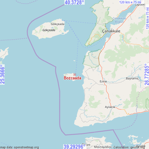
Bozcaada GPS coordinates[2]
39° 50' 6" North, 26° 4' 10.992" East
| Map corner | latitude | longitude |
|---|---|---|
| Upper-left | 40.3728°, | 25.3666° |
| Center: | 39.835°, | 26.06972° |
| Lower-right: | 39.29296°, | 26.77285° |
| Map W x H: | 120.1×120.1 km | = 74.6×74.6mi |
| max Lat: | 42.02683° ⇑33.6% North |
| Bozcaada: | 39.835° |
| min Lat: | ⇓66.4% South 35.9025° |
| min Long | Bozcaada | max Long |
| 25.90902° | 26.06972° | 44.60099° |
| W 0%⇐ | ⇒100% E |
Elevation
Elevation of Bozcaada is 12 m = 39 ft, and this is 705.4 m = 2314 ft below average elevation for this country.
| Max E: |
2682 m = 8799 ft | 96.8% |
| Avg. | 717.4 m = 2354 ft | |
| Bozcaada | 12 m = 39 ft | |
Min E: |
0 m = 0 ft | 3.2% |
See also: Turkey elevation on elevation.city.
Geographical zone
Bozcaada is located in North temperate zone (between Tropic of Cancer and the Arctic Circle). Distance of this Northern Tropic circle is 1823.3 km =1132.9 mi to South.| Distance of | km | miles | from Bozcaada |
|---|---|---|---|
| North Pole | 5577.8 | 3465.9 | to North |
| Arctic Circle | 2971.9 | 1846.7 | to North |
| Tropic Cancer | 1823.3 | 1132.9 | to South |
| Equator | 4429.2 | 2752.2 | to South |


Nearby cities:
15 places around Bozcaada: (largest is in red/bold)
• Ayvacık
38.7 km =24 mi,  132°
132°
• Bayramiç
46.2 km =28.7 mi,  93°
93°
• Behram
44.2 km =27.5 mi,  149°
149°
• Eceabat
45.9 km =28.5 mi,  32°
32°
• Evciler
60.3 km =37.5 mi,  96°
96°
• Ezine
23.8 km =14.8 mi, 103°
• Geyikli
12.2 km =7.6 mi,  105°
105°
• Gökçeada
42.9 km =26.7 mi,  341°
341°
• Gülpınar
33.9 km =21.1 mi,  172°
172°
• Kirazlı
58.5 km =36.4 mi,  66°
66°
• Küçükkuyu
55.8 km =34.7 mi,  124°
124°
• Merkez
44.4 km =27.6 mi,  42°
42°
• Yiğitler
46.4 km =28.8 mi, 85°
• Çanakkale
46.1 km =28.6 mi, 39°
• İntepe
29.9 km =18.6 mi,  48°
48°
In other languages:
- In France: Ténédos
- In Italian: Distretto di Tenedo
- In Russian: Бозджаада
- In Chinese: 博茲賈島
Sources, notices
• [Note1] Compared only with cities in Turkey existing in our database
• [Src1] Map data: © OpenStreetMap contributors (CC-BY-SA)
• [Src2] Other city data from geonames.org with taken over terms of usage.
• [Src3] Geographical zone / Annual Mean Temperature by Robert A. Rohde @ Wikipedia
