Kırobası geodata
Kırobası (Mersin) is a seat of a third-order administrative division; located in Turkey in Europe/Istanbul (GMT+3) time zone. In our database, there are 1323 cities with bigger population. Compared to other cities in Turkey, 94.8% of cities are located further ↑North; 58.8% of cities are located further →East and 88.3% of cities have lower elevation than Kırobası. Note1


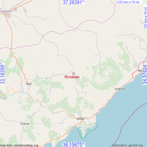
Kırobası GPS coordinates[2]
36° 43' 20.64" North, 33° 52' 1.596" East
| Map corner | latitude | longitude |
|---|---|---|
| Upper-left | 37.28391°, | 33.16399° |
| Center: | 36.7224°, | 33.86711° |
| Lower-right: | 36.15675°, | 34.57024° |
| Map W x H: | 125.3×125.3 km | = 77.9×77.9mi |
| max Lat: | 42.02683° ⇑94.8% North |
| Kırobası: | 36.7224° |
| min Lat: | ⇓5.2% South 35.9025° |
| min Long | Kırobası | max Long |
| 25.90902° | 33.86711° | 44.60099° |
| W 41.2%⇐ | ⇒58.8% E |
Elevation
Elevation of Kırobası is 1410 m = 4626 ft, and this is 692.6 m = 2272 ft above average elevation for this country.
| Max E: |
2682 m = 8799 ft | 11.7% |
| Kırobası | 1410 m 4626 ft | |
| Avg. | 717.4 m = 2354 ft | |
Min E: |
0 m = 0 ft | 88.3% |
See also: Turkey elevation on elevation.city.
Geographical zone
Kırobası is located in North temperate zone (between Tropic of Cancer and the Arctic Circle). Distance of this Northern Tropic circle is 1477.2 km =917.9 mi to South.| Distance of | km | miles | from Kırobası |
|---|---|---|---|
| North Pole | 5923.9 | 3680.9 | to North |
| Arctic Circle | 3318 | 2061.7 | to North |
| Tropic Cancer | 1477.2 | 917.9 | to South |
| Equator | 4083.1 | 2537.1 | to South |


Nearby cities:
15 places around Kırobası: (largest is in red/bold)
• Akdere
54.6 km =33.9 mi,  191°
191°
• Arslanköy
49.8 km =30.9 mi,  48°
48°
• Elvanlı
45.2 km =28.1 mi,  92°
92°
• Erdemli
41.5 km =25.8 mi,  108°
108°
• Güzeloluk
20.8 km =12.9 mi,  67°
67°
• Kocahasanlı
39.4 km =24.5 mi, 112°
• Kuzucubelen
52.5 km =32.6 mi,  75°
75°
• Kızkalesi
38 km =23.6 mi,  139°
139°
• Mezitli
58.5 km =36.4 mi, 87°
• Mut
39.2 km =24.4 mi,  257°
257°
• Pınarbaşı
44.2 km =27.5 mi, 92°
• Sarıkavak
25.4 km =15.8 mi,  231°
231°
• Silifke
38.8 km =24.1 mi,  171°
171°
• Taşucu
44.6 km =27.7 mi,  178°
178°
• Yeşildere
57.6 km =35.8 mi,  327°
327°
Sources, notices
• [Note1] Compared only with cities in Turkey existing in our database
• [Src1] Map data: © OpenStreetMap contributors (CC-BY-SA)
• [Src2] Other city data from geonames.org with taken over terms of usage.
• [Src3] Geographical zone / Annual Mean Temperature by Robert A. Rohde @ Wikipedia
