Üçpınar geodata
Üçpınar (Manisa) is a seat of a third-order administrative division; located in Turkey in Europe/Istanbul (GMT+3) time zone. In our database, there are 1323 cities with bigger population. Compared to other cities in Turkey, 50.7% of cities are located further ↓South; 94.5% of cities are located further →East and 84.2% of cities have higher elevation than Üçpınar. Note1


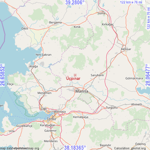
Üçpınar GPS coordinates[2]
38° 44' 3.228" North, 27° 21' 41.904" East
| Map corner | latitude | longitude |
|---|---|---|
| Upper-left | 39.2806°, | 26.65852° |
| Center: | 38.73423°, | 27.36164° |
| Lower-right: | 38.18365°, | 28.06477° |
| Map W x H: | 122×122 km | = 75.8×75.8mi |
| max Lat: | 42.02683° ⇑49.3% North |
| Üçpınar: | 38.73423° |
| min Lat: | ⇓50.7% South 35.9025° |
| min Long | Üçpınar | max Long |
| 25.90902° | 27.36164° | 44.60099° |
| W 5.5%⇐ | ⇒94.5% E |
Elevation
Elevation of Üçpınar is 78 m = 256 ft, and this is 639.4 m = 2098 ft below average elevation for this country.
| Max E: |
2682 m = 8799 ft | 84.2% |
| Avg. | 717.4 m = 2354 ft | |
| Üçpınar | 78 m = 256 ft | |
Min E: |
0 m = 0 ft | 15.8% |
See also: Turkey elevation on elevation.city.
Geographical zone
Üçpınar is located in North temperate zone (between Tropic of Cancer and the Arctic Circle). Distance of this Northern Tropic circle is 1700.9 km =1056.9 mi to South.| Distance of | km | miles | from Üçpınar |
|---|---|---|---|
| North Pole | 5700.2 | 3541.9 | to North |
| Arctic Circle | 3094.3 | 1922.7 | to North |
| Tropic Cancer | 1700.9 | 1056.9 | to South |
| Equator | 4306.8 | 2676.1 | to South |


Nearby cities:
15 places around Üçpınar: (largest is in red/bold)
• Aliağa
34.6 km =21.5 mi,  282°
282°
• Bayraklı
34.3 km =21.3 mi,  210°
210°
• Bornova
30.3 km =18.8 mi,  200°
200°
• Emiralem
23.3 km =14.5 mi,  233°
233°
• Halitpaşa
28 km =17.4 mi,  101°
101°
• Karaoğlanlı
28.9 km =18 mi,  142°
142°
• Kemalpaşa
34.6 km =21.5 mi,  171°
171°
• Manisa
14.7 km =9.1 mi,  157°
157°
• Menemen
29 km =18 mi,  240°
240°
• Muradiye
8.5 km =5.3 mi,  193°
193°
• Osmancalı
9.9 km =6.2 mi,  288°
288°
• Saruhanlı
17.9 km =11.1 mi,  89°
89°
• Yenişakran
30.6 km =19 mi,  303°
303°
• Yuntdağ
25.4 km =15.8 mi,  329°
329°
• Zeytindağ
36 km =22.4 mi,  315°
315°
Sources, notices
• [Note1] Compared only with cities in Turkey existing in our database
• [Src1] Map data: © OpenStreetMap contributors (CC-BY-SA)
• [Src2] Other city data from geonames.org with taken over terms of usage.
• [Src3] Geographical zone / Annual Mean Temperature by Robert A. Rohde @ Wikipedia
