Aliağa geodata
Aliağa (İzmir) is a seat of a second-order administrative division; located in Turkey in Europe/Istanbul (GMT+3) time zone. With population of 44,883 people, there are 191 cities with bigger population in this country. Compared to other cities in Turkey, 51.9% of cities are located further ↓South; 97.2% of cities are located further →East and 93.2% of cities have higher elevation than Aliağa. Note1


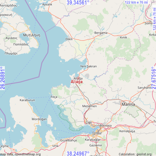
Aliağa GPS coordinates[2]
38° 47' 59.1" North, 26° 58' 19.308" East
| Map corner | latitude | longitude |
|---|---|---|
| Upper-left | 39.34561°, | 26.26891° |
| Center: | 38.79975°, | 26.97203° |
| Lower-right: | 38.24967°, | 27.67516° |
| Map W x H: | 121.9×121.9 km | = 75.7×75.7mi |
| max Lat: | 42.02683° ⇑48.1% North |
| Aliağa: | 38.79975° |
| min Lat: | ⇓51.9% South 35.9025° |
| min Long | Aliağa | max Long |
| 25.90902° | 26.97203° | 44.60099° |
| W 2.8%⇐ | ⇒97.2% E |
Elevation
Elevation of Aliağa is 24 m = 79 ft, and this is 693.4 m = 2275 ft below average elevation for this country.
| Max E: |
2682 m = 8799 ft | 93.2% |
| Avg. | 717.4 m = 2354 ft | |
| Aliağa | 24 m = 79 ft | |
Min E: |
0 m = 0 ft | 6.8% |
See also: Aliağa elevation on elevation.city.
Geographical zone
Aliağa is located in North temperate zone (between Tropic of Cancer and the Arctic Circle). Distance of this Northern Tropic circle is 1708.2 km =1061.4 mi to South.| Distance of | km | miles | from Aliağa |
|---|---|---|---|
| North Pole | 5692.9 | 3537.4 | to North |
| Arctic Circle | 3087 | 1918.2 | to North |
| Tropic Cancer | 1708.2 | 1061.4 | to South |
| Equator | 4314.1 | 2680.7 | to South |


Nearby cities:
15 places around Aliağa: (largest is in red/bold)
• Bayraklı
40.6 km =25.2 mi,  155°
155°
• Bergama
40 km =24.9 mi,  26°
26°
• Dikili
31 km =19.3 mi,  346°
346°
• Emiralem
26 km =16.2 mi,  144°
144°
• Foça
23.6 km =14.7 mi,  232°
232°
• Karşıyaka
39.9 km =24.8 mi, 162°
• Menemen
23 km =14.3 mi, 158°
• Muradiye
35.4 km =22 mi,  116°
116°
• Osmancalı
24.7 km =15.3 mi,  99°
99°
• Yenifoça
14.1 km =8.8 mi,  238°
238°
• Yenişakran
12.7 km =7.9 mi,  40°
40°
• Yuntdağ
25.5 km =15.8 mi,  54°
54°
• Zeytindağ
20.5 km =12.7 mi,  24°
24°
• Çandarlı
15.4 km =9.6 mi, 347°
• Üçpınar
34.6 km =21.5 mi, 102°
Sources, notices
• [Note1] Compared only with cities in Turkey existing in our database
• [Src1] Map data: © OpenStreetMap contributors (CC-BY-SA)
• [Src2] Other city data from geonames.org with taken over terms of usage.
• [Src3] Geographical zone / Annual Mean Temperature by Robert A. Rohde @ Wikipedia
