Doğubayazıt geodata
Doğubayazıt (Ağrı) is a seat of a second-order administrative division; located in Turkey in Europe/Istanbul (GMT+3) time zone. With population of 70,171 people, there are 134 cities with bigger population in this country. Compared to other cities in Turkey, 62% of cities are located further ↓South; 99.6% of cities are located further ←West and 93.3% of cities have lower elevation than Doğubayazıt. Note1


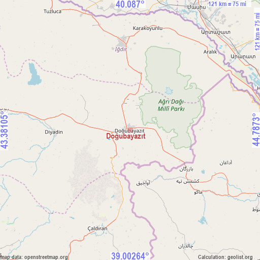
Doğubayazıt GPS coordinates[2]
39° 32' 48.984" North, 44° 5' 3.012" East
| Map corner | latitude | longitude |
|---|---|---|
| Upper-left | 40.087°, | 43.38105° |
| Center: | 39.54694°, | 44.08417° |
| Lower-right: | 39.00264°, | 44.7873° |
| Map W x H: | 120.6×120.6 km | = 74.9×74.9mi |
| max Lat: | 42.02683° ⇑38% North |
| Doğubayazıt: | 39.54694° |
| min Lat: | ⇓62% South 35.9025° |
| min Long | Doğubayazıt | max Long |
| 25.90902° | 44.08417° | 44.60099° |
| W 99.6%⇐ | ⇒0.40000000000001% E |
Elevation
Elevation of Doğubayazıt is 1592 m = 5223 ft, and this is 874.6 m = 2869 ft above average elevation for this country.
| Max E: |
2682 m = 8799 ft | 6.7% |
| Doğubayazıt | 1592 m 5223 ft | |
| Avg. | 717.4 m = 2354 ft | |
Min E: |
0 m = 0 ft | 93.3% |
See also: Doğubayazıt elevation on elevation.city.
Geographical zone
Doğubayazıt is located in North temperate zone (between Tropic of Cancer and the Arctic Circle). Distance of this Northern Tropic circle is 1791.3 km =1113.1 mi to South.| Distance of | km | miles | from Doğubayazıt |
|---|---|---|---|
| North Pole | 5609.9 | 3485.8 | to North |
| Arctic Circle | 3004 | 1866.6 | to North |
| Tropic Cancer | 1791.3 | 1113.1 | to South |
| Equator | 4397.2 | 2732.3 | to South |


Nearby cities:
15 places around Doğubayazıt: (largest is in red/bold)
• Aralık
51.9 km =32.2 mi,  45°
45°
• Deliçay
73 km =45.4 mi,  224°
224°
• Diyadin
35.4 km =22 mi,  268°
268°
• Dorutay
83.1 km =51.6 mi,  181°
181°
• Erciş
85.1 km =52.9 mi,  227°
227°
• Gaziler
80.3 km =49.9 mi,  317°
317°
• Iğdır
42 km =26.1 mi,  355°
355°
• Karakoyunlu
52.9 km =32.9 mi,  312°
312°
• Muradiye
68.6 km =42.6 mi,  204°
204°
• Murat
73.7 km =45.8 mi,  280°
280°
• Suluçem
28.3 km =17.6 mi, 305°
• Taşburun
50.3 km =31.3 mi,  13°
13°
• Taşlıçay
62 km =38.5 mi, 278°
• Tuzluca
66 km =41 mi,  325°
325°
• Çaldıran
47.3 km =29.4 mi, 198°
In other languages:
- In France: Doğubeyazıt
- In German: Doğubeyazıt
- In Italian: Dogubayazit
- In Russian: Догубаязит
Sources, notices
• [Note1] Compared only with cities in Turkey existing in our database
• [Src1] Map data: © OpenStreetMap contributors (CC-BY-SA)
• [Src2] Other city data from geonames.org with taken over terms of usage.
• [Src3] Geographical zone / Annual Mean Temperature by Robert A. Rohde @ Wikipedia
