Çaldıran geodata
Çaldıran (Van) is a seat of a second-order administrative division; located in Turkey in Europe/Istanbul (GMT+3) time zone. In our database, there are 1323 cities with bigger population. Compared to other cities in Turkey, 56.6% of cities are located further ↓South; 99.3% of cities are located further ←West and 99.2% of cities have lower elevation than Çaldıran. Note1


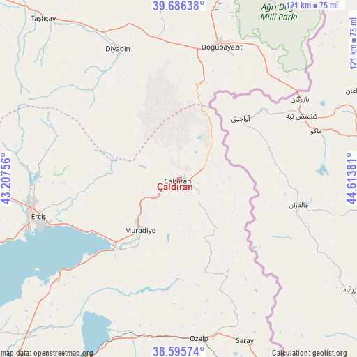
Çaldıran GPS coordinates[2]
39° 8' 35.412" North, 43° 54' 38.448" East
| Map corner | latitude | longitude |
|---|---|---|
| Upper-left | 39.68638°, | 43.20756° |
| Center: | 39.14317°, | 43.91068° |
| Lower-right: | 38.59574°, | 44.61381° |
| Map W x H: | 121.3×121.3 km | = 75.4×75.4mi |
| max Lat: | 42.02683° ⇑43.4% North |
| Çaldıran: | 39.14317° |
| min Lat: | ⇓56.6% South 35.9025° |
| min Long | Çaldıran | max Long |
| 25.90902° | 43.91068° | 44.60099° |
| W 99.3%⇐ | ⇒0.7% E |
Elevation
Elevation of Çaldıran is 2050 m = 6726 ft, and this is 1332.6 m = 4372 ft above average elevation for this country.
| Max E: |
2682 m = 8799 ft | 0.8% |
| Çaldıran | 2050 m 6726 ft | |
| Avg. | 717.4 m = 2354 ft | |
Min E: |
0 m = 0 ft | 99.2% |
See also: Turkey elevation on elevation.city.
Geographical zone
Çaldıran is located in North temperate zone (between Tropic of Cancer and the Arctic Circle). Distance of this Northern Tropic circle is 1746.4 km =1085.2 mi to South.| Distance of | km | miles | from Çaldıran |
|---|---|---|---|
| North Pole | 5654.7 | 3513.7 | to North |
| Arctic Circle | 3048.9 | 1894.5 | to North |
| Tropic Cancer | 1746.4 | 1085.2 | to South |
| Equator | 4352.3 | 2704.4 | to South |


Nearby cities:
15 places around Çaldıran: (largest is in red/bold)
• Dedeli
73.8 km =45.9 mi,  272°
272°
• Deliçay
37.3 km =23.2 mi,  259°
259°
• Diyadin
48.7 km =30.3 mi,  335°
335°
• Dorutay
40.6 km =25.2 mi,  160°
160°
• Doğubayazıt
47.3 km =29.4 mi,  18°
18°
• Erciş
49.3 km =30.6 mi,  254°
254°
• Erçek
59.4 km =36.9 mi,  202°
202°
• Kocapınar
61.9 km =38.5 mi, 265°
• Muradiye
22.2 km =13.8 mi,  217°
217°
• Murat
82.4 km =51.2 mi,  315°
315°
• Saray
59.3 km =36.8 mi, 158°
• Suluçem
61.8 km =38.4 mi,  352°
352°
• Taşlıçay
71.4 km =44.4 mi, 319°
• Timar
54.1 km =33.6 mi,  229°
229°
• Özalp
54.7 km =34 mi,  172°
172°
Sources, notices
• [Note1] Compared only with cities in Turkey existing in our database
• [Src1] Map data: © OpenStreetMap contributors (CC-BY-SA)
• [Src2] Other city data from geonames.org with taken over terms of usage.
• [Src3] Geographical zone / Annual Mean Temperature by Robert A. Rohde @ Wikipedia
